Banugao geodata
Banugao (Calabarzon) is a populated place; located in Philippines in Asia/Manila (GMT+8) time zone. With population of 2,795 people, there are 2797 cities with bigger population in this country. Compared to other cities in Philippines, 75.4% of cities are located further ↓South; 65.1% of cities are located further →East and 60.8% of cities have higher elevation than Banugao. Note1


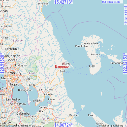
Banugao GPS coordinates[2]
14° 44' 53.7" North, 121° 37' 6.24" East
| Map corner | latitude | longitude |
|---|---|---|
| Upper-left | 15.42713°, | 120.91528° |
| Center: | 14.74825°, | 121.6184° |
| Lower-right: | 14.06724°, | 122.32153° |
| Map W x H: | 151.2×151.2 km | = 94×94mi |
| max Lat: | 20.78733° ⇑24.6% North |
| Banugao: | 14.74825° |
| min Lat: | ⇓75.4% South 4.65442° |
| min Long | Banugao | max Long |
| 117.04868° | 121.6184° | 126.58417° |
| W 34.9%⇐ | ⇒65.1% E |
Elevation
Elevation of Banugao is 16 m = 52 ft, and this is 71.9 m = 236 ft below average elevation for this country.
| Max E: |
2262 m = 7421 ft | 60.8% |
| Avg. | 87.9 m = 288 ft | |
| Banugao | 16 m = 52 ft | |
Min E: |
-2 m = -7 ft | 39.2% |
See also: Philippines elevation on elevation.city.
Geographical zone
Banugao is located in North Torrid zone (between Equator and Tropic of Cancer). Distance of this Northern Tropic circle is 966.1 km =600.3 mi to North.| Distance of | km | miles | from Banugao |
|---|---|---|---|
| North Pole | 8367.2 | 5199.1 | to North |
| Arctic Circle | 5761.3 | 3579.9 | to North |
| Tropic Cancer | 966.1 | 600.3 | to North |
| Equator | 1639.9 | 1019 | to South |


Nearby cities:
15 places around Banugao: (largest is in red/bold)
• Bantilan
5.6 km =3.5 mi,  78°
78°
• Binulasan
8.7 km =5.4 mi,  102°
102°
• Daraitan
25.8 km =16 mi,  231°
231°
• Dinahican
11.1 km =6.9 mi,  108°
108°
• General Nakar
2.5 km =1.6 mi,  47°
47°
• Gumian
4.2 km =2.6 mi,  179°
179°
• Infanta
3.4 km =2.1 mi, 96°
• Kapatalan
33.5 km =20.8 mi,  204°
204°
• Kiloloran
12.6 km =7.8 mi,  186°
186°
• Panukulan
29.7 km =18.5 mi, 45°
• Polillo
35.7 km =22.2 mi, 95°
• Pulo
4.1 km =2.5 mi,  157°
157°
• Real
9.5 km =5.9 mi, 189°
• Sibulan
33.9 km =21.1 mi,  89°
89°
• Tignoan
20.4 km =12.7 mi, 180°
Sources, notices
• [Note1] Compared only with cities in Philippines existing in our database
• [Src1] Map data: © OpenStreetMap contributors (CC-BY-SA)
• [Src2] Other city data from geonames.org with taken over terms of usage.
• [Src3] Geographical zone / Annual Mean Temperature by Robert A. Rohde @ Wikipedia
