Balingasag geodata
Balingasag (Northern Mindanao) is a seat of a third-order administrative division; located in Philippines in Asia/Manila (GMT+8) time zone. With population of 9,722 people, there are 630 cities with bigger population in this country. Compared to other cities in Philippines, 77.1% of cities are located further ↑North; 83.7% of cities are located further ←West and 98.1% of cities have higher elevation than Balingasag. Note1
Administrative division(s):
- Level 1: Northern Mindanao
- Level 2: Province of Misamis Oriental
- Level 3: Balingasag


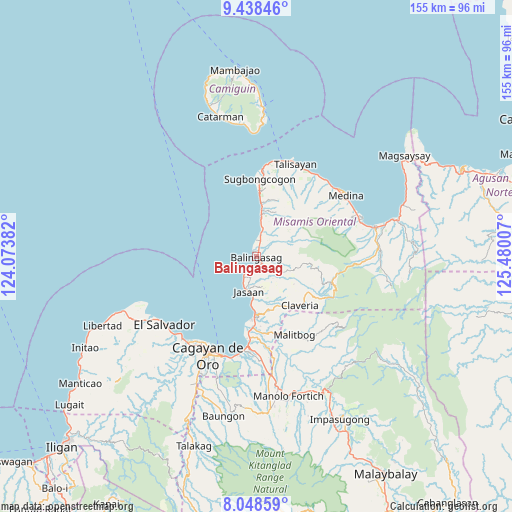
Balingasag GPS coordinates[2]
8° 44' 39.012" North, 124° 46' 36.984" East
| Map corner | latitude | longitude |
|---|---|---|
| Upper-left | 9.43846°, | 124.07382° |
| Center: | 8.74417°, | 124.77694° |
| Lower-right: | 8.04859°, | 125.48007° |
| Map W x H: | 154.5×154.5 km | = 96×96mi |
| max Lat: | 20.78733° ⇑77.1% North |
| Balingasag: | 8.74417° |
| min Lat: | ⇓22.9% South 4.65442° |
| min Long | Balingasag | max Long |
| 117.04868° | 124.77694° | 126.58417° |
| W 83.7%⇐ | ⇒16.3% E |
Elevation
Elevation of Balingasag is 3 m = 10 ft, and this is 84.9 m = 279 ft below average elevation for this country.
| Max E: |
2262 m = 7421 ft | 98.1% |
| Avg. | 87.9 m = 288 ft | |
| Balingasag | 3 m = 10 ft | |
Min E: |
-2 m = -7 ft | 1.9% |
See also: Philippines elevation on elevation.city.
Geographical zone
Balingasag is located in North Torrid zone (between Equator and Tropic of Cancer). Distance of Equator is 972.3 km =604.2 mi to South.| Distance of | km | miles | from Balingasag |
|---|---|---|---|
| North Pole | 9034.8 | 5614 | to North |
| Arctic Circle | 6428.9 | 3994.7 | to North |
| Tropic Cancer | 1633.7 | 1015.1 | to North |
| Equator | 972.3 | 604.2 | to South |


Nearby cities:
15 places around Balingasag: (largest is in red/bold)
• Aplaya
15.1 km =9.4 mi,  183°
183°
• Baliwagan
3.2 km =2 mi,  152°
152°
• Binitinan
3.8 km =2.4 mi, 182°
• Hinapalanan
15.7 km =9.8 mi,  137°
137°
• Inobulan
15.9 km =9.9 mi,  7°
7°
• Jasaan
10.3 km =6.4 mi,  193°
193°
• Kauswagan
5.1 km =3.2 mi,  358°
358°
• Lagonglong
7.2 km =4.5 mi, 11°
• Looc
11.1 km =6.9 mi, 8°
• Mambayaan
4.4 km =2.7 mi, 10°
• Mandangoa
3.5 km =2.2 mi,  26°
26°
• Napalitan
4.4 km =2.7 mi,  38°
38°
• Salay
12.9 km =8 mi, 5°
• Solana
13.5 km =8.4 mi, 182°
• Taboc
15.1 km =9.4 mi, 8°
Sources, notices
• [Note1] Compared only with cities in Philippines existing in our database
• [Src1] Map data: © OpenStreetMap contributors (CC-BY-SA)
• [Src2] Other city data from geonames.org with taken over terms of usage.
• [Src3] Geographical zone / Annual Mean Temperature by Robert A. Rohde @ Wikipedia
