Balamban geodata
Balamban (Central Visayas) is a seat of a third-order administrative division; located in Philippines in Asia/Manila (GMT+8) time zone. With population of 22,283 people, there are 347 cities with bigger population in this country. Compared to other cities in Philippines, 63.3% of cities are located further ↑North; 66% of cities are located further ←West and 98.1% of cities have higher elevation than Balamban. Note1


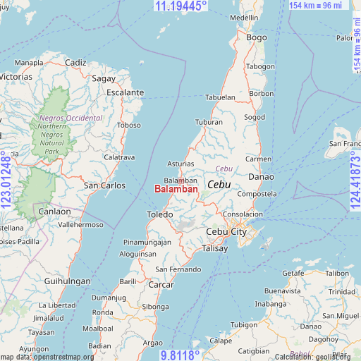
Balamban GPS coordinates[2]
10° 30' 14.04" North, 123° 42' 56.16" East
| Map corner | latitude | longitude |
|---|---|---|
| Upper-left | 11.19445°, | 123.01248° |
| Center: | 10.5039°, | 123.7156° |
| Lower-right: | 9.8118°, | 124.41873° |
| Map W x H: | 153.7×153.7 km | = 95.5×95.5mi |
| max Lat: | 20.78733° ⇑63.3% North |
| Balamban: | 10.5039° |
| min Lat: | ⇓36.7% South 4.65442° |
| min Long | Balamban | max Long |
| 117.04868° | 123.7156° | 126.58417° |
| W 66%⇐ | ⇒34% E |
Elevation
Elevation of Balamban is 3 m = 10 ft, and this is 84.9 m = 279 ft below average elevation for this country.
| Max E: |
2262 m = 7421 ft | 98.1% |
| Avg. | 87.9 m = 288 ft | |
| Balamban | 3 m = 10 ft | |
Min E: |
-2 m = -7 ft | 1.9% |
See also: Philippines elevation on elevation.city.
Geographical zone
Balamban is located in North Torrid zone (between Equator and Tropic of Cancer). Distance of Equator is 1167.9 km =725.7 mi to South.| Distance of | km | miles | from Balamban |
|---|---|---|---|
| North Pole | 8839.1 | 5492.4 | to North |
| Arctic Circle | 6233.2 | 3873.1 | to North |
| Tropic Cancer | 1438 | 893.5 | to North |
| Equator | 1167.9 | 725.7 | to South |


Nearby cities:
15 places around Balamban: (largest is in red/bold)
• Agsungot
22.2 km =13.8 mi,  110°
110°
• Asturias
7 km =4.3 mi,  0°
0°
• Biasong
3.1 km =1.9 mi,  46°
46°
• Buanoy
4.4 km =2.7 mi,  202°
202°
• Carmelo
23.9 km =14.9 mi,  20°
20°
• Colonia
18.7 km =11.6 mi,  26°
26°
• Langob
8.3 km =5.2 mi,  11°
11°
• Lunas
15.7 km =9.8 mi, 14°
• Nangka
3.2 km =2 mi, 7°
• Owak
5.4 km =3.4 mi,  341°
341°
• San Isidro
5.6 km =3.5 mi, 20°
• San Roque
11.6 km =7.2 mi, 15°
• Santa Nino
22.1 km =13.7 mi, 21°
• Toledo
16.4 km =10.2 mi,  210°
210°
• Tubigagmanoc
14.3 km =8.9 mi, 14°
Sources, notices
• [Note1] Compared only with cities in Philippines existing in our database
• [Src1] Map data: © OpenStreetMap contributors (CC-BY-SA)
• [Src2] Other city data from geonames.org with taken over terms of usage.
• [Src3] Geographical zone / Annual Mean Temperature by Robert A. Rohde @ Wikipedia
