Agsungot geodata
Agsungot (Central Visayas) is a populated place; located in Philippines in Asia/Manila (GMT+8) time zone. With population of 1,981 people, there are 4161 cities with bigger population in this country. Compared to other cities in Philippines, 63.8% of cities are located further ↑North; 69.4% of cities are located further ←West and 91.9% of cities have lower elevation than Agsungot. Note1


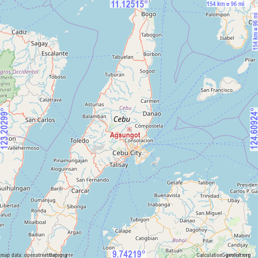
Agsungot GPS coordinates[2]
10° 26' 3.984" North, 123° 54' 21.996" East
| Map corner | latitude | longitude |
|---|---|---|
| Upper-left | 11.12515°, | 123.20299° |
| Center: | 10.43444°, | 123.90611° |
| Lower-right: | 9.74219°, | 124.60924° |
| Map W x H: | 153.8×153.8 km | = 95.6×95.6mi |
| max Lat: | 20.78733° ⇑63.8% North |
| Agsungot: | 10.43444° |
| min Lat: | ⇓36.2% South 4.65442° |
| min Long | Agsungot | max Long |
| 117.04868° | 123.90611° | 126.58417° |
| W 69.4%⇐ | ⇒30.6% E |
Elevation
Elevation of Agsungot is 282 m = 925 ft, and this is 194.1 m = 637 ft above average elevation for this country.
| Max E: |
2262 m = 7421 ft | 8.1% |
| Agsungot | 282 m 925 ft | |
| Avg. | 87.9 m = 288 ft | |
Min E: |
-2 m = -7 ft | 91.9% |
See also: Philippines elevation on elevation.city.
Geographical zone
Agsungot is located in North Torrid zone (between Equator and Tropic of Cancer). Distance of Equator is 1160.2 km =720.9 mi to South.| Distance of | km | miles | from Agsungot |
|---|---|---|---|
| North Pole | 8846.9 | 5497.2 | to North |
| Arctic Circle | 6241 | 3878 | to North |
| Tropic Cancer | 1445.7 | 898.3 | to North |
| Equator | 1160.2 | 720.9 | to South |


Nearby cities:
15 places around Agsungot: (largest is in red/bold)
• Apas
10.4 km =6.5 mi,  182°
182°
• Baugo
13.1 km =8.1 mi,  173°
173°
• Calero
12.1 km =7.5 mi,  124°
124°
• Cebu City
13.2 km =8.2 mi,  187°
187°
• Cogon Cruz
10.9 km =6.8 mi,  39°
39°
• Compostela
11.7 km =7.3 mi,  78°
78°
• Consolacion
8.5 km =5.3 mi,  138°
138°
• Kabungahan
12.4 km =7.7 mi, 42°
• Kotkot
10.4 km =6.5 mi,  95°
95°
• Liloan
10.9 km =6.8 mi,  111°
111°
• Magay
12.4 km =7.7 mi,  70°
70°
• Mandaue City
12.4 km =7.7 mi, 171°
• Masaba
12.8 km =8 mi,  31°
31°
• Sandayong Sur
12.2 km =7.6 mi,  56°
56°
• Tayud
12.4 km =7.7 mi, 119°
Sources, notices
• [Note1] Compared only with cities in Philippines existing in our database
• [Src1] Map data: © OpenStreetMap contributors (CC-BY-SA)
• [Src2] Other city data from geonames.org with taken over terms of usage.
• [Src3] Geographical zone / Annual Mean Temperature by Robert A. Rohde @ Wikipedia
