Toledo geodata
Toledo (Central Visayas) is a populated place; located in Philippines in Asia/Manila (GMT+8) time zone. With population of 156,916 people, there are 64 cities with bigger population in this country. Compared to other cities in Philippines, 64.4% of cities are located further ↑North; 64.5% of cities are located further ←West and 98.8% of cities have higher elevation than Toledo. Note1


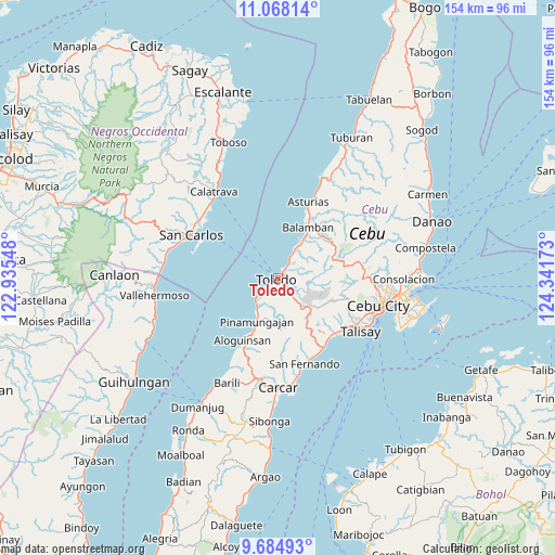
Toledo GPS coordinates[2]
10° 22' 38.28" North, 123° 38' 18.96" East
| Map corner | latitude | longitude |
|---|---|---|
| Upper-left | 11.06814°, | 122.93548° |
| Center: | 10.3773°, | 123.6386° |
| Lower-right: | 9.68493°, | 124.34173° |
| Map W x H: | 153.8×153.8 km | = 95.6×95.6mi |
| max Lat: | 20.78733° ⇑64.4% North |
| Toledo: | 10.3773° |
| min Lat: | ⇓35.6% South 4.65442° |
| min Long | Toledo | max Long |
| 117.04868° | 123.6386° | 126.58417° |
| W 64.5%⇐ | ⇒35.5% E |
Elevation
Elevation of Toledo is 2 m = 7 ft, and this is 85.9 m = 282 ft below average elevation for this country.
| Max E: |
2262 m = 7421 ft | 98.8% |
| Avg. | 87.9 m = 288 ft | |
| Toledo | 2 m = 7 ft | |
Min E: |
-2 m = -7 ft | 1.2% |
See also: Toledo elevation on elevation.city.
Geographical zone
Toledo is located in North Torrid zone (between Equator and Tropic of Cancer). Distance of Equator is 1153.8 km =716.9 mi to South.| Distance of | km | miles | from Toledo |
|---|---|---|---|
| North Pole | 8853.2 | 5501.1 | to North |
| Arctic Circle | 6247.3 | 3881.9 | to North |
| Tropic Cancer | 1452.1 | 902.3 | to North |
| Equator | 1153.8 | 716.9 | to South |


Nearby cities:
15 places around Toledo: (largest is in red/bold)
• Alpaco
15.6 km =9.7 mi,  162°
162°
• Balamban
16.4 km =10.2 mi,  30°
30°
• Bonbon
19.2 km =11.9 mi,  207°
207°
• Buanoy
12.1 km =7.5 mi, 33°
• Cantao-an
19.3 km =12 mi,  140°
140°
• Cogon
17.9 km =11.1 mi,  132°
132°
• Guindarohan
19 km =11.8 mi, 132°
• Kuanos
18.7 km =11.6 mi,  124°
124°
• Lanas
16.1 km =10 mi, 139°
• Lut-od
13.4 km =8.3 mi,  184°
184°
• Nangka
19.4 km =12.1 mi, 27°
• Pinamungahan
13.3 km =8.3 mi, 206°
• Tajao
9.2 km =5.7 mi,  220°
220°
• Tutay
15.9 km =9.9 mi,  203°
203°
• Uling
13.3 km =8.3 mi, 144°
Sources, notices
• [Note1] Compared only with cities in Philippines existing in our database
• [Src1] Map data: © OpenStreetMap contributors (CC-BY-SA)
• [Src2] Other city data from geonames.org with taken over terms of usage.
• [Src3] Geographical zone / Annual Mean Temperature by Robert A. Rohde @ Wikipedia
