Caramutan geodata
Caramutan (Ilocos) is a populated place; located in Philippines in Asia/Manila (GMT+8) time zone. With population of 6,524 people, there are 963 cities with bigger population in this country. Compared to other cities in Philippines, 86.4% of cities are located further ↓South; 87.8% of cities are located further →East and 58.1% of cities have lower elevation than Caramutan. Note1


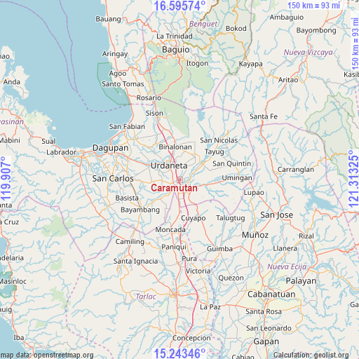
Caramutan GPS coordinates[2]
15° 55' 14.664" North, 120° 36' 36.432" East
| Map corner | latitude | longitude |
|---|---|---|
| Upper-left | 16.59574°, | 119.907° |
| Center: | 15.92074°, | 120.61012° |
| Lower-right: | 15.24346°, | 121.31325° |
| Map W x H: | 150.4×150.4 km | = 93.5×93.5mi |
| max Lat: | 20.78733° ⇑13.6% North |
| Caramutan: | 15.92074° |
| min Lat: | ⇓86.4% South 4.65442° |
| min Long | Caramutan | max Long |
| 117.04868° | 120.61012° | 126.58417° |
| W 12.2%⇐ | ⇒87.8% E |
Elevation
Elevation of Caramutan is 31 m = 102 ft, and this is 56.9 m = 187 ft below average elevation for this country.
| Max E: |
2262 m = 7421 ft | 41.9% |
| Avg. | 87.9 m = 288 ft | |
| Caramutan | 31 m = 102 ft | |
Min E: |
-2 m = -7 ft | 58.1% |
See also: Philippines elevation on elevation.city.
Geographical zone
Caramutan is located in North Torrid zone (between Equator and Tropic of Cancer). Distance of this Northern Tropic circle is 835.7 km =519.3 mi to North.| Distance of | km | miles | from Caramutan |
|---|---|---|---|
| North Pole | 8236.8 | 5118.1 | to North |
| Arctic Circle | 5631 | 3498.9 | to North |
| Tropic Cancer | 835.7 | 519.3 | to North |
| Equator | 1770.2 | 1100 | to South |


Nearby cities:
15 places around Caramutan: (largest is in red/bold)
• Bacag
3.2 km =2 mi,  289°
289°
• Bactad Proper
6.4 km =4 mi,  0°
0°
• Capulaan
8 km =5 mi,  257°
257°
• Carmen
4 km =2.5 mi,  196°
196°
• Carusucan
5.7 km =3.5 mi,  28°
28°
• Gueset
4.1 km =2.5 mi,  37°
37°
• Puelay
5.4 km =3.4 mi,  226°
226°
• Rosales
3.8 km =2.4 mi,  140°
140°
• Salcedo
7.1 km =4.4 mi,  188°
188°
• Samon
4.6 km =2.9 mi,  70°
70°
• Sanlibo
6.4 km =4 mi,  265°
265°
• Tombod
4.7 km =2.9 mi,  284°
284°
• Unzad
7.6 km =4.7 mi, 268°
• Urdaneta
7.4 km =4.6 mi,  325°
325°
• Villasis
3.2 km =2 mi, 227°
Sources, notices
• [Note1] Compared only with cities in Philippines existing in our database
• [Src1] Map data: © OpenStreetMap contributors (CC-BY-SA)
• [Src2] Other city data from geonames.org with taken over terms of usage.
• [Src3] Geographical zone / Annual Mean Temperature by Robert A. Rohde @ Wikipedia
