Atulayan geodata
Atulayan (Cagayan Valley) is a populated place; located in Philippines in Asia/Manila (GMT+8) time zone. With population of 6,374 people, there are 981 cities with bigger population in this country. Compared to other cities in Philippines, 97% of cities are located further ↓South; 64.2% of cities are located further →East and 53.5% of cities have lower elevation than Atulayan. Note1


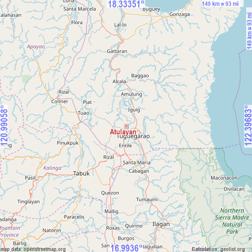
Atulayan GPS coordinates[2]
17° 39' 53.28" North, 121° 41' 37.32" East
| Map corner | latitude | longitude |
|---|---|---|
| Upper-left | 18.33351°, | 120.99058° |
| Center: | 17.6648°, | 121.6937° |
| Lower-right: | 16.9936°, | 122.39683° |
| Map W x H: | 149×149 km | = 92.6×92.6mi |
| max Lat: | 20.78733° ⇑3% North |
| Atulayan: | 17.6648° |
| min Lat: | ⇓97% South 4.65442° |
| min Long | Atulayan | max Long |
| 117.04868° | 121.6937° | 126.58417° |
| W 35.8%⇐ | ⇒64.2% E |
Elevation
Elevation of Atulayan is 26 m = 85 ft, and this is 61.9 m = 203 ft below average elevation for this country.
| Max E: |
2262 m = 7421 ft | 46.5% |
| Avg. | 87.9 m = 288 ft | |
| Atulayan | 26 m = 85 ft | |
Min E: |
-2 m = -7 ft | 53.5% |
See also: Philippines elevation on elevation.city.
Geographical zone
Atulayan is located in North Torrid zone (between Equator and Tropic of Cancer). Distance of this Northern Tropic circle is 641.8 km =398.8 mi to North.| Distance of | km | miles | from Atulayan |
|---|---|---|---|
| North Pole | 8042.9 | 4997.6 | to North |
| Arctic Circle | 5437 | 3378.4 | to North |
| Tropic Cancer | 641.8 | 398.8 | to North |
| Equator | 1964.1 | 1220.4 | to South |


Nearby cities:
15 places around Atulayan: (largest is in red/bold)
• Bauan
6.6 km =4.1 mi,  347°
347°
• Carig
5.3 km =3.3 mi,  96°
96°
• Dassun
9.1 km =5.7 mi,  11°
11°
• Gadu
9.7 km =6 mi,  245°
245°
• Gammad
7.3 km =4.5 mi,  46°
46°
• Iguig
10.6 km =6.6 mi,  25°
25°
• Iraga
5.8 km =3.6 mi,  314°
314°
• Lanna
3.5 km =2.2 mi, 11°
• Larion Alto
8 km =5 mi,  118°
118°
• Maddarulug Norte
6.6 km =4.1 mi,  195°
195°
• Nattapian
1.5 km =0.9 mi,  39°
39°
• Peñablanca
9.9 km =6.2 mi,  110°
110°
• Solana
1.4 km =0.9 mi,  192°
192°
• Tuguegarao
6.3 km =3.9 mi,  150°
150°
• Ugac Sur
6.2 km =3.9 mi,  157°
157°
Sources, notices
• [Note1] Compared only with cities in Philippines existing in our database
• [Src1] Map data: © OpenStreetMap contributors (CC-BY-SA)
• [Src2] Other city data from geonames.org with taken over terms of usage.
• [Src3] Geographical zone / Annual Mean Temperature by Robert A. Rohde @ Wikipedia
