Iguig geodata
Iguig (Cagayan Valley) is a seat of a third-order administrative division; located in Philippines in Asia/Manila (GMT+8) time zone. With population of 3,274 people, there are 2237 cities with bigger population in this country. Compared to other cities in Philippines, 97.6% of cities are located further ↓South; 63.5% of cities are located further →East and 55.6% of cities have lower elevation than Iguig. Note1


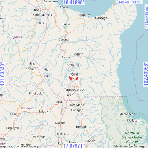
Iguig GPS coordinates[2]
17° 45' 2.16" North, 121° 44' 11.22" East
| Map corner | latitude | longitude |
|---|---|---|
| Upper-left | 18.41898°, | 121.03333° |
| Center: | 17.7506°, | 121.73645° |
| Lower-right: | 17.07971°, | 122.43958° |
| Map W x H: | 148.9×148.9 km | = 92.5×92.5mi |
| max Lat: | 20.78733° ⇑2.4% North |
| Iguig: | 17.7506° |
| min Lat: | ⇓97.6% South 4.65442° |
| min Long | Iguig | max Long |
| 117.04868° | 121.73645° | 126.58417° |
| W 36.5%⇐ | ⇒63.5% E |
Elevation
Elevation of Iguig is 28 m = 92 ft, and this is 59.9 m = 197 ft below average elevation for this country.
| Max E: |
2262 m = 7421 ft | 44.4% |
| Avg. | 87.9 m = 288 ft | |
| Iguig | 28 m = 92 ft | |
Min E: |
-2 m = -7 ft | 55.6% |
See also: Philippines elevation on elevation.city.
Geographical zone
Iguig is located in North Torrid zone (between Equator and Tropic of Cancer). Distance of this Northern Tropic circle is 632.2 km =392.8 mi to North.| Distance of | km | miles | from Iguig |
|---|---|---|---|
| North Pole | 8033.4 | 4991.7 | to North |
| Arctic Circle | 5427.5 | 3372.5 | to North |
| Tropic Cancer | 632.2 | 392.8 | to North |
| Equator | 1973.7 | 1226.4 | to South |


Nearby cities:
15 places around Iguig: (largest is in red/bold)
• Aggugaddah
9 km =5.6 mi,  128°
128°
• Amulung
9.6 km =6 mi,  351°
351°
• Atulayan
10.6 km =6.6 mi,  205°
205°
• Bauan
6.7 km =4.2 mi,  242°
242°
• Carig
10.2 km =6.3 mi,  175°
175°
• Dassun
2.7 km =1.7 mi,  257°
257°
• Dodan
13.6 km =8.5 mi,  153°
153°
• Estefania
5.6 km =3.5 mi, 345°
• Gammad
4.5 km =2.8 mi,  170°
170°
• Iraga
10.2 km =6.3 mi, 237°
• Lanna
7.2 km =4.5 mi, 212°
• Minanga Norte
1.3 km =0.8 mi,  325°
325°
• Nattapian
9.1 km =5.7 mi,  202°
202°
• Quibal
8.8 km =5.5 mi,  115°
115°
• Solana
11.9 km =7.4 mi, 203°
Sources, notices
• [Note1] Compared only with cities in Philippines existing in our database
• [Src1] Map data: © OpenStreetMap contributors (CC-BY-SA)
• [Src2] Other city data from geonames.org with taken over terms of usage.
• [Src3] Geographical zone / Annual Mean Temperature by Robert A. Rohde @ Wikipedia
