Allangigan Primero geodata
Allangigan Primero (Ilocos) is a populated place; located in Philippines in Asia/Manila (GMT+8) time zone. With population of 2,219 people, there are 3849 cities with bigger population in this country. Compared to other cities in Philippines, 94.6% of cities are located further ↓South; 91% of cities are located further →East and 54.4% of cities have lower elevation than Allangigan Primero. Note1


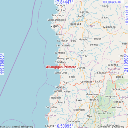
Allangigan Primero GPS coordinates[2]
17° 10' 26.148" North, 120° 29' 31.02" East
| Map corner | latitude | longitude |
|---|---|---|
| Upper-left | 17.84447°, | 119.78883° |
| Center: | 17.17393°, | 120.49195° |
| Lower-right: | 16.50095°, | 121.19508° |
| Map W x H: | 149.4×149.4 km | = 92.8×92.8mi |
| max Lat: | 20.78733° ⇑5.4% North |
| Allangigan Primero: | 17.17393° |
| min Lat: | ⇓94.6% South 4.65442° |
| min Long | Allangigan Prim | max Long |
| 117.04868° | 120.49195° | 126.58417° |
| W 9%⇐ | ⇒91% E |
Elevation
Elevation of Allangigan Primero is 27 m = 89 ft, and this is 60.9 m = 200 ft below average elevation for this country.
| Max E: |
2262 m = 7421 ft | 45.6% |
| Avg. | 87.9 m = 288 ft | |
| Allangigan Primero | 27 m = 89 ft | |
Min E: |
-2 m = -7 ft | 54.4% |
See also: Philippines elevation on elevation.city.
Geographical zone
Allangigan Primero is located in North Torrid zone (between Equator and Tropic of Cancer). Distance of this Northern Tropic circle is 696.4 km =432.7 mi to North.| Distance of | km | miles | from Allangigan Primero |
|---|---|---|---|
| North Pole | 8097.5 | 5031.6 | to North |
| Arctic Circle | 5491.6 | 3412.3 | to North |
| Tropic Cancer | 696.4 | 432.7 | to North |
| Equator | 1909.6 | 1186.6 | to South |


Nearby cities:
15 places around Allangigan Primero: (largest is in red/bold)
• Banayoyo
6.7 km =4.2 mi,  352°
352°
• Calongbuyan
7 km =4.3 mi,  261°
261°
• Candon
4.9 km =3 mi,  298°
298°
• Caterman
8.6 km =5.3 mi, 303°
• Darapidap
8.4 km =5.2 mi,  290°
290°
• Galimuyod
2.4 km =1.5 mi, 298°
• Gregorio del Pilar
13.6 km =8.5 mi,  110°
110°
• Lidlidda
11.1 km =6.9 mi,  16°
16°
• Parioc Segundo
2.8 km =1.7 mi,  272°
272°
• Patpata Segundo
6.3 km =3.9 mi,  279°
279°
• Salcedo
5.5 km =3.4 mi, 112°
• San Emilio
14 km =8.7 mi,  65°
65°
• Santa Cruz
10.7 km =6.6 mi,  203°
203°
• Santa Lucia
7.5 km =4.7 mi,  213°
213°
• Tablac
6.1 km =3.8 mi,  319°
319°
Sources, notices
• [Note1] Compared only with cities in Philippines existing in our database
• [Src1] Map data: © OpenStreetMap contributors (CC-BY-SA)
• [Src2] Other city data from geonames.org with taken over terms of usage.
• [Src3] Geographical zone / Annual Mean Temperature by Robert A. Rohde @ Wikipedia
