Salcedo geodata
Salcedo (Ilocos) is a seat of a third-order administrative division; located in Philippines in Asia/Manila (GMT+8) time zone. In our database, there are 4166 cities with bigger population. Compared to other cities in Philippines, 94.4% of cities are located further ↓South; 89.8% of cities are located further →East and 79.4% of cities have lower elevation than Salcedo. Note1
Administrative division(s):
- Level 1: Ilocos
- Level 2: Province of Ilocos Sur
- Level 3: Salcedo (Baugen)


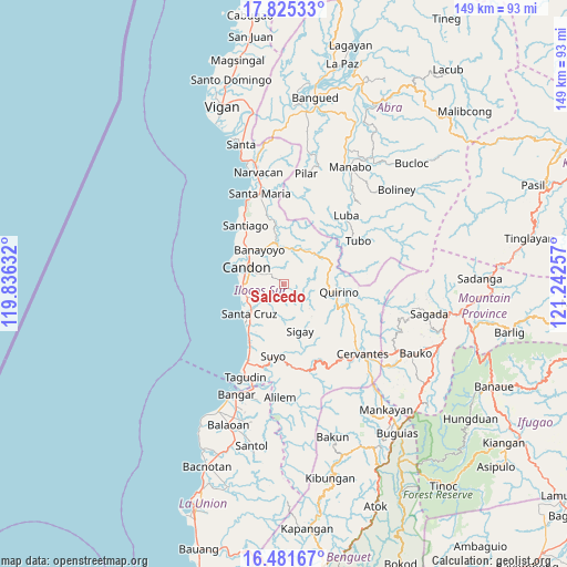
Salcedo GPS coordinates[2]
17° 9' 16.992" North, 120° 32' 21.984" East
| Map corner | latitude | longitude |
|---|---|---|
| Upper-left | 17.82533°, | 119.83632° |
| Center: | 17.15472°, | 120.53944° |
| Lower-right: | 16.48167°, | 121.24257° |
| Map W x H: | 149.4×149.4 km | = 92.8×92.8mi |
| max Lat: | 20.78733° ⇑5.6% North |
| Salcedo: | 17.15472° |
| min Lat: | ⇓94.4% South 4.65442° |
| min Long | Salcedo | max Long |
| 117.04868° | 120.53944° | 126.58417° |
| W 10.2%⇐ | ⇒89.8% E |
Elevation
Elevation of Salcedo is 88 m = 289 ft, and this is 0.099999999999994 m = 0 ft above average elevation for this country.
| Max E: |
2262 m = 7421 ft | 20.6% |
| Salcedo | 88 m 289 ft | |
| Avg. | 87.9 m = 288 ft | |
Min E: |
-2 m = -7 ft | 79.4% |
See also: Philippines elevation on elevation.city.
Geographical zone
Salcedo is located in North Torrid zone (between Equator and Tropic of Cancer). Distance of this Northern Tropic circle is 698.5 km =434 mi to North.| Distance of | km | miles | from Salcedo |
|---|---|---|---|
| North Pole | 8099.6 | 5032.9 | to North |
| Arctic Circle | 5493.7 | 3413.6 | to North |
| Tropic Cancer | 698.5 | 434 | to North |
| Equator | 1907.4 | 1185.2 | to South |


Nearby cities:
15 places around Salcedo: (largest is in red/bold)
• Allangigan Primero
5.5 km =3.4 mi,  292°
292°
• Banayoyo
10.6 km =6.6 mi,  325°
325°
• Calongbuyan
12 km =7.5 mi,  275°
275°
• Candon
10.3 km =6.4 mi,  295°
295°
• Darapidap
13.8 km =8.6 mi, 291°
• Galimuyod
7.9 km =4.9 mi, 294°
• Gregorio del Pilar
8.2 km =5.1 mi,  109°
109°
• Lidlidda
12.9 km =8 mi,  351°
351°
• Parioc Segundo
8.1 km =5 mi, 286°
• Patpata Segundo
11.7 km =7.3 mi, 285°
• San Emilio
11 km =6.8 mi,  44°
44°
• Santa Cruz
12 km =7.5 mi,  230°
230°
• Santa Lucia
10.1 km =6.3 mi,  245°
245°
• Sigay
10.2 km =6.3 mi,  140°
140°
• Tablac
11.3 km =7 mi,  306°
306°
Sources, notices
• [Note1] Compared only with cities in Philippines existing in our database
• [Src1] Map data: © OpenStreetMap contributors (CC-BY-SA)
• [Src2] Other city data from geonames.org with taken over terms of usage.
• [Src3] Geographical zone / Annual Mean Temperature by Robert A. Rohde @ Wikipedia
