Alijis geodata
Alijis (Western Visayas) is a populated place; located in Philippines in Asia/Manila (GMT+8) time zone. With population of 2,132 people, there are 4027 cities with bigger population in this country. Compared to other cities in Philippines, 63.6% of cities are located further ↑North; 50.4% of cities are located further ←West and 92.7% of cities have higher elevation than Alijis. Note1
Administrative division(s):
- Level 1: Western Visayas
- Level 2: Province of Negros Occidental
- Level 3: Valladolid


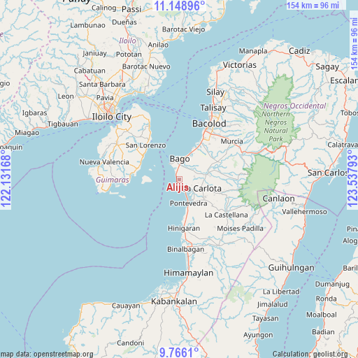
Alijis GPS coordinates[2]
10° 27' 29.88" North, 122° 50' 5.28" East
| Map corner | latitude | longitude |
|---|---|---|
| Upper-left | 11.14896°, | 122.13168° |
| Center: | 10.4583°, | 122.8348° |
| Lower-right: | 9.7661°, | 123.53793° |
| Map W x H: | 153.8×153.8 km | = 95.6×95.6mi |
| max Lat: | 20.78733° ⇑63.6% North |
| Alijis: | 10.4583° |
| min Lat: | ⇓36.4% South 4.65442° |
| min Long | Alijis | max Long |
| 117.04868° | 122.8348° | 126.58417° |
| W 50.4%⇐ | ⇒49.6% E |
Elevation
Elevation of Alijis is 6 m = 20 ft, and this is 81.9 m = 269 ft below average elevation for this country.
| Max E: |
2262 m = 7421 ft | 92.7% |
| Avg. | 87.9 m = 288 ft | |
| Alijis | 6 m = 20 ft | |
Min E: |
-2 m = -7 ft | 7.3% |
See also: Philippines elevation on elevation.city.
Geographical zone
Alijis is located in North Torrid zone (between Equator and Tropic of Cancer). Distance of Equator is 1162.9 km =722.6 mi to South.| Distance of | km | miles | from Alijis |
|---|---|---|---|
| North Pole | 8844.2 | 5495.5 | to North |
| Arctic Circle | 6238.3 | 3876.3 | to North |
| Tropic Cancer | 1443.1 | 896.7 | to North |
| Equator | 1162.9 | 722.6 | to South |


Nearby cities:
15 places around Alijis: (largest is in red/bold)
• Bago City
8.3 km =5.2 mi,  358°
358°
• Bagumbayan
1.4 km =0.9 mi,  180°
180°
• Baliwagan
9.2 km =5.7 mi,  137°
137°
• Banga
4.9 km =3 mi,  352°
352°
• Caridad
8.1 km =5 mi,  58°
58°
• Himaya
0.8 km =0.5 mi,  198°
198°
• Napoles
8.6 km =5.3 mi,  53°
53°
• Pacol
2.2 km =1.4 mi,  245°
245°
• Pontevedra
10 km =6.2 mi,  158°
158°
• Pulupandan
7.8 km =4.8 mi,  332°
332°
• Sagasa
6.6 km =4.1 mi,  80°
80°
• San Enrique
5 km =3.1 mi, 160°
• San Juan
8.6 km =5.3 mi, 157°
• Sibucao
7.3 km =4.5 mi,  128°
128°
• Valladolid
1.2 km =0.7 mi,  288°
288°
Sources, notices
• [Note1] Compared only with cities in Philippines existing in our database
• [Src1] Map data: © OpenStreetMap contributors (CC-BY-SA)
• [Src2] Other city data from geonames.org with taken over terms of usage.
• [Src3] Geographical zone / Annual Mean Temperature by Robert A. Rohde @ Wikipedia
