Baliwagan geodata
Baliwagan (Western Visayas) is a populated place; located in Philippines in Asia/Manila (GMT+8) time zone. With population of 2,883 people, there are 2661 cities with bigger population in this country. Compared to other cities in Philippines, 64.2% of cities are located further ↑North; 51.5% of cities are located further ←West and 80.7% of cities have higher elevation than Baliwagan. Note1
Administrative division(s):
- Level 1: Western Visayas
- Level 2: Province of Negros Occidental
- Level 3: San Enrique


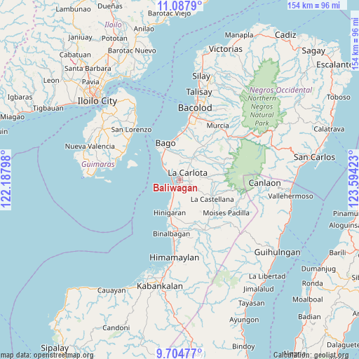
Baliwagan GPS coordinates[2]
10° 23' 49.56" North, 122° 53' 27.96" East
| Map corner | latitude | longitude |
|---|---|---|
| Upper-left | 11.0879°, | 122.18798° |
| Center: | 10.3971°, | 122.8911° |
| Lower-right: | 9.70477°, | 123.59423° |
| Map W x H: | 153.8×153.8 km | = 95.6×95.6mi |
| max Lat: | 20.78733° ⇑64.2% North |
| Baliwagan: | 10.3971° |
| min Lat: | ⇓35.8% South 4.65442° |
| min Long | Baliwagan | max Long |
| 117.04868° | 122.8911° | 126.58417° |
| W 51.5%⇐ | ⇒48.5% E |
Elevation
Elevation of Baliwagan is 9 m = 30 ft, and this is 78.9 m = 259 ft below average elevation for this country.
| Max E: |
2262 m = 7421 ft | 80.7% |
| Avg. | 87.9 m = 288 ft | |
| Baliwagan | 9 m = 30 ft | |
Min E: |
-2 m = -7 ft | 19.3% |
See also: Philippines elevation on elevation.city.
Geographical zone
Baliwagan is located in North Torrid zone (between Equator and Tropic of Cancer). Distance of Equator is 1156 km =718.3 mi to South.| Distance of | km | miles | from Baliwagan |
|---|---|---|---|
| North Pole | 8851 | 5499.8 | to North |
| Arctic Circle | 6245.1 | 3880.5 | to North |
| Tropic Cancer | 1449.9 | 900.9 | to North |
| Equator | 1156 | 718.3 | to South |


Nearby cities:
15 places around Baliwagan: (largest is in red/bold)
• Alijis
9.2 km =5.7 mi,  317°
317°
• Antipolo
9.2 km =5.7 mi,  119°
119°
• Bagumbayan
8.2 km =5.1 mi,  311°
311°
• Canroma
4.3 km =2.7 mi,  198°
198°
• Carmen Grande
3.4 km =2.1 mi,  127°
127°
• Himaya
8.8 km =5.5 mi, 313°
• La Carlota
4.5 km =2.8 mi,  47°
47°
• Miranda
10.4 km =6.5 mi,  188°
188°
• Pacol
10 km =6.2 mi, 305°
• Pontevedra
3.5 km =2.2 mi,  225°
225°
• Sagasa
7.9 km =4.9 mi,  2°
2°
• San Enrique
4.9 km =3 mi,  295°
295°
• San Juan
3.1 km =1.9 mi,  247°
247°
• Sibucao
2.4 km =1.5 mi,  349°
349°
• Valladolid
10.2 km =6.3 mi, 314°
Sources, notices
• [Note1] Compared only with cities in Philippines existing in our database
• [Src1] Map data: © OpenStreetMap contributors (CC-BY-SA)
• [Src2] Other city data from geonames.org with taken over terms of usage.
• [Src3] Geographical zone / Annual Mean Temperature by Robert A. Rohde @ Wikipedia
