Alicante geodata
Alicante (Western Visayas) is a populated place; located in Philippines in Asia/Manila (GMT+8) time zone. With population of 8,607 people, there are 720 cities with bigger population in this country. Compared to other cities in Philippines, 58.1% of cities are located further ↑North; 53.6% of cities are located further ←West and 80.7% of cities have higher elevation than Alicante. Note1
Administrative division(s):
- Level 1: Western Visayas
- Level 2: Province of Negros Occidental
- Level 3: Enrique B. Magalona (Saravia)


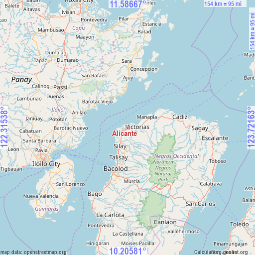
Alicante GPS coordinates[2]
10° 53' 49.344" North, 123° 1' 6.6" East
| Map corner | latitude | longitude |
|---|---|---|
| Upper-left | 11.58667°, | 122.31538° |
| Center: | 10.89704°, | 123.0185° |
| Lower-right: | 10.20581°, | 123.72163° |
| Map W x H: | 153.5×153.5 km | = 95.4×95.4mi |
| max Lat: | 20.78733° ⇑58.1% North |
| Alicante: | 10.89704° |
| min Lat: | ⇓41.9% South 4.65442° |
| min Long | Alicante | max Long |
| 117.04868° | 123.0185° | 126.58417° |
| W 53.6%⇐ | ⇒46.4% E |
Elevation
Elevation of Alicante is 9 m = 30 ft, and this is 78.9 m = 259 ft below average elevation for this country.
| Max E: |
2262 m = 7421 ft | 80.7% |
| Avg. | 87.9 m = 288 ft | |
| Alicante | 9 m = 30 ft | |
Min E: |
-2 m = -7 ft | 19.3% |
See also: Philippines elevation on elevation.city.
Geographical zone
Alicante is located in North Torrid zone (between Equator and Tropic of Cancer). Distance of Equator is 1211.6 km =752.9 mi to South.| Distance of | km | miles | from Alicante |
|---|---|---|---|
| North Pole | 8795.4 | 5465.2 | to North |
| Arctic Circle | 6189.5 | 3846 | to North |
| Tropic Cancer | 1394.3 | 866.4 | to North |
| Equator | 1211.6 | 752.9 | to South |


Nearby cities:
15 places around Alicante: (largest is in red/bold)
• Alacaygan
7.7 km =4.8 mi,  145°
145°
• Bay-ang
17.5 km =10.9 mi,  331°
331°
• Binonga
14.5 km =9 mi,  196°
196°
• Dos Hermanas
17.4 km =10.8 mi,  173°
173°
• Eustaquio Lopez
9 km =5.6 mi,  163°
163°
• Imbang
11.2 km =7 mi,  178°
178°
• Madalag
3.9 km =2.4 mi,  273°
273°
• Manapla
13.3 km =8.3 mi,  59°
59°
• Nangka
5 km =3.1 mi, 157°
• San Pablo
13.6 km =8.5 mi,  82°
82°
• Saravia
6 km =3.7 mi,  248°
248°
• Tanza
7 km =4.3 mi,  186°
186°
• Tortosa
8.8 km =5.5 mi, 62°
• Victorias
5.7 km =3.5 mi, 84°
• Viejo Daan Banua
4.6 km =2.9 mi, 80°
Sources, notices
• [Note1] Compared only with cities in Philippines existing in our database
• [Src1] Map data: © OpenStreetMap contributors (CC-BY-SA)
• [Src2] Other city data from geonames.org with taken over terms of usage.
• [Src3] Geographical zone / Annual Mean Temperature by Robert A. Rohde @ Wikipedia
