Victorias geodata
Victorias (Western Visayas) is a seat of a third-order administrative division; located in Philippines in Asia/Manila (GMT+8) time zone. With population of 86,510 people, there are 105 cities with bigger population in this country. Compared to other cities in Philippines, 58% of cities are located further ↑North; 54.6% of cities are located further ←West and 70.2% of cities have higher elevation than Victorias. Note1
Administrative division(s):
- Level 1: Western Visayas
- Level 2: Province of Negros Occidental
- Level 3: City of Victorias


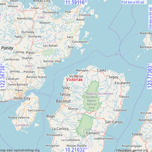
Victorias GPS coordinates[2]
10° 54' 5.544" North, 123° 4' 13.8" East
| Map corner | latitude | longitude |
|---|---|---|
| Upper-left | 11.59116°, | 122.36738° |
| Center: | 10.90154°, | 123.0705° |
| Lower-right: | 10.21032°, | 123.77363° |
| Map W x H: | 153.5×153.5 km | = 95.4×95.4mi |
| max Lat: | 20.78733° ⇑58% North |
| Victorias: | 10.90154° |
| min Lat: | ⇓42% South 4.65442° |
| min Long | Victorias | max Long |
| 117.04868° | 123.0705° | 126.58417° |
| W 54.6%⇐ | ⇒45.4% E |
Elevation
Elevation of Victorias is 12 m = 39 ft, and this is 75.9 m = 249 ft below average elevation for this country.
| Max E: |
2262 m = 7421 ft | 70.2% |
| Avg. | 87.9 m = 288 ft | |
| Victorias | 12 m = 39 ft | |
Min E: |
-2 m = -7 ft | 29.8% |
See also: Victorias elevation on elevation.city.
Geographical zone
Victorias is located in North Torrid zone (between Equator and Tropic of Cancer). Distance of Equator is 1212.1 km =753.2 mi to South.| Distance of | km | miles | from Victorias |
|---|---|---|---|
| North Pole | 8794.9 | 5464.9 | to North |
| Arctic Circle | 6189 | 3845.7 | to North |
| Tropic Cancer | 1393.8 | 866.1 | to North |
| Equator | 1212.1 | 753.2 | to South |


Nearby cities:
15 places around Victorias: (largest is in red/bold)
• Alacaygan
7 km =4.3 mi,  191°
191°
• Alicante
5.7 km =3.5 mi,  264°
264°
• Binonga
17.4 km =10.8 mi,  213°
213°
• Capitan Ramon
16.4 km =10.2 mi,  162°
162°
• Chambrey
13.6 km =8.5 mi,  51°
51°
• Eustaquio Lopez
9.7 km =6 mi,  199°
199°
• Imbang
12.8 km =8 mi, 204°
• Madalag
9.6 km =6 mi,  268°
268°
• Manapla
8.5 km =5.3 mi,  42°
42°
• Nangka
6.3 km =3.9 mi,  216°
216°
• San Pablo
7.9 km =4.9 mi,  81°
81°
• Saravia
11.5 km =7.1 mi, 256°
• Tanza
9.9 km =6.2 mi, 221°
• Tortosa
4.1 km =2.5 mi,  31°
31°
• Viejo Daan Banua
1.2 km =0.7 mi,  280°
280°
Sources, notices
• [Note1] Compared only with cities in Philippines existing in our database
• [Src1] Map data: © OpenStreetMap contributors (CC-BY-SA)
• [Src2] Other city data from geonames.org with taken over terms of usage.
• [Src3] Geographical zone / Annual Mean Temperature by Robert A. Rohde @ Wikipedia
