San Pablo geodata
San Pablo (Western Visayas) is a populated place; located in Philippines in Asia/Manila (GMT+8) time zone. With population of 8,046 people, there are 766 cities with bigger population in this country. Compared to other cities in Philippines, 57.9% of cities are located further ↑North; 55.6% of cities are located further ←West and 72.2% of cities have lower elevation than San Pablo. Note1
Administrative division(s):
- Level 1: Western Visayas
- Level 2: Province of Negros Occidental
- Level 3: Manapla


San Pablo GPS coordinates[2]
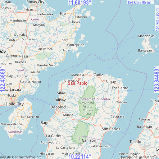
10° 54' 44.424" North, 123° 8' 30.48" East
| Map corner | latitude | longitude |
|---|---|---|
| Upper-left | 11.60193°, | 122.43868° |
| Center: | 10.91234°, | 123.1418° |
| Lower-right: | 10.22114°, | 123.84493° |
| Map W x H: | 153.5×153.5 km | = 95.4×95.4mi |
| max Lat: | 20.78733° ⇑57.9% North |
| San Pablo: | 10.91234° |
| min Lat: | ⇓42.1% South 4.65442° |
| min Long | San Pablo | max Long |
| 117.04868° | 123.1418° | 126.58417° |
| W 55.6%⇐ | ⇒44.4% E |
Elevation
Elevation of San Pablo is 58 m = 190 ft, and this is 29.9 m = 98 ft below average elevation for this country.
| Max E: |
2262 m = 7421 ft | 27.8% |
| Avg. | 87.9 m = 288 ft | |
| San Pablo | 58 m = 190 ft | |
Min E: |
-2 m = -7 ft | 72.2% |
See also: Philippines elevation on elevation.city.
Geographical zone
San Pablo is located in North Torrid zone (between Equator and Tropic of Cancer). Distance of Equator is 1213.3 km =753.9 mi to South.| Distance of | km | miles | from San Pablo |
|---|---|---|---|
| North Pole | 8793.7 | 5464.2 | to North |
| Arctic Circle | 6187.8 | 3844.9 | to North |
| Tropic Cancer | 1392.6 | 865.3 | to North |
| Equator | 1213.3 | 753.9 | to South |


Nearby cities:
15 places around San Pablo: (largest is in red/bold)
• Alacaygan
12.1 km =7.5 mi,  228°
228°
• Alicante
13.6 km =8.5 mi,  262°
262°
• Andres Bonifacio
11.8 km =7.3 mi,  87°
87°
• Cadiz
16.4 km =10.2 mi,  76°
76°
• Capitan Ramon
17.2 km =10.7 mi,  189°
189°
• Chambrey
7.7 km =4.8 mi,  21°
21°
• Eustaquio Lopez
15.1 km =9.4 mi, 226°
• Luna
12.6 km =7.8 mi,  60°
60°
• Madalag
17.4 km =10.8 mi,  265°
265°
• Manapla
5.5 km =3.4 mi,  338°
338°
• Nangka
13.2 km =8.2 mi,  241°
241°
• Tanza
16.7 km =10.4 mi, 238°
• Tortosa
6.1 km =3.8 mi,  292°
292°
• Victorias
7.9 km =4.9 mi, 261°
• Viejo Daan Banua
9 km =5.6 mi, 263°
Sources, notices
• [Note1] Compared only with cities in Philippines existing in our database
• [Src1] Map data: © OpenStreetMap contributors (CC-BY-SA)
• [Src2] Other city data from geonames.org with taken over terms of usage.
• [Src3] Geographical zone / Annual Mean Temperature by Robert A. Rohde @ Wikipedia
