Wrocław geodata
Wrocław (Lower Silesia) is a seat of a first-order administrative division; located in Poland in Europe/Warsaw (GMT+2) time zone. With population of 634,893 people, there are 3 cities with bigger population in this country. Compared to other cities in Poland, 52.5% of cities are located further ↑North; 84.3% of cities are located further →East and 71.1% of cities have higher elevation than Wrocław. Note1


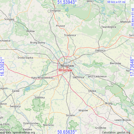
Wrocław GPS coordinates[2]
51° 6' 0" North, 17° 1' 59.988" East
| Map corner | latitude | longitude |
|---|---|---|
| Upper-left | 51.53943°, | 16.33021° |
| Center: | 51.1°, | 17.03333° |
| Lower-right: | 50.65635°, | 17.73646° |
| Map W x H: | 98.2×98.2 km | = 61×61mi |
| max Lat: | 54.83135° ⇑52.5% North |
| Wrocław: | 51.1° |
| min Lat: | ⇓47.5% South 49.21328° |
| min Long | Wrocław | max Long |
| 14.20249° | 17.03333° | 24.03723° |
| W 15.7%⇐ | ⇒84.3% E |
Elevation
Elevation of Wrocław is 119 m = 390 ft, and this is 72.4 m = 238 ft below average elevation for this country.
| Max E: |
974 m = 3196 ft | 71.1% |
| Avg. | 191.4 m = 628 ft | |
| Wrocław | 119 m = 390 ft | |
Min E: |
-3 m = -10 ft | 28.9% |
See also: Wrocław elevation on elevation.city.
Geographical zone
Wrocław is located in North temperate zone (between Tropic of Cancer and the Arctic Circle). Distance of this North polar circle is 1719.4 km =1068.4 mi to North.| Distance of | km | miles | from Wrocław |
|---|---|---|---|
| North Pole | 4325.3 | 2687.6 | to North |
| Arctic Circle | 1719.4 | 1068.4 | to North |
| Tropic Cancer | 3075.9 | 1911.3 | to South |
| Equator | 5681.8 | 3530.5 | to South |


Nearby cities:
15 places around Wrocław: (largest is in red/bold)
• Dąbie
3.4 km =2.1 mi,  79°
79°
• Grabiszynek
3.6 km =2.2 mi,  246°
246°
• Osiedle Henrykowskie
1.8 km =1.1 mi,  129°
129°
• Partynice
3.8 km =2.4 mi,  200°
200°
• Powstańców Śląskich Wschód
1.1 km =0.7 mi,  212°
212°
• Powstańców Śląskich Zachód-Centrum Południow
1.2 km =0.7 mi, 248°
• Rejon placu Grunwaldzkiego
2.7 km =1.7 mi,  46°
46°
• Rejon placu Świętego Macieja
2.3 km =1.4 mi,  7°
7°
• Rejon ulicy Borowskiej-Południe
2.7 km =1.7 mi,  191°
191°
• Rejon ulicy Klęczkowskiej
3.3 km =2.1 mi,  0°
0°
• Rejon ulicy Mieleckiej
2.4 km =1.5 mi, 246°
• Rejon ulicy Saperów
2.8 km =1.7 mi,  236°
236°
• Rejon ulicy Traugutta
1.1 km =0.7 mi, 75°
• Szczytniki
3.6 km =2.2 mi,  65°
65°
• Zacisze
3.9 km =2.4 mi, 48°
In other languages:
- In Spanish: Breslavia
- In German: Breslau
- In Italian: Breslavia
- In Russian: Вроцлав
- In Chinese: 弗罗茨瓦夫
Sources, notices
• [Note1] Compared only with cities in Poland existing in our database
• [Src1] Map data: © OpenStreetMap contributors (CC-BY-SA)
• [Src2] Other city data from geonames.org with taken over terms of usage.
• [Src3] Geographical zone / Annual Mean Temperature by Robert A. Rohde @ Wikipedia
