Zacisze geodata
Zacisze (Lower Silesia) is a section of populated place; located in Poland in Europe/Warsaw (GMT+2) time zone. With population of 1,773 people, there are 1642 cities with bigger population in this country. Compared to other cities in Poland, 51.7% of cities are located further ↑North; 83.6% of cities are located further →East and 72.6% of cities have higher elevation than Zacisze. Note1
Administrative division(s):
- Level 1: Lower Silesia
- Level 2: Wrocław
- Level 3: Wrocław
- Level 4: Zacisze - Zalesie - Szczytniki


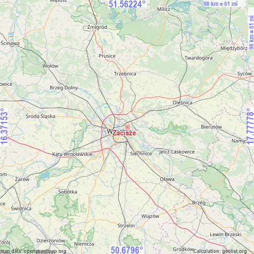
Zacisze GPS coordinates[2]
51° 7' 22.908" North, 17° 4' 28.74" East
| Map corner | latitude | longitude |
|---|---|---|
| Upper-left | 51.56224°, | 16.37153° |
| Center: | 51.12303°, | 17.07465° |
| Lower-right: | 50.6796°, | 17.77778° |
| Map W x H: | 98.1×98.1 km | = 61×61mi |
| max Lat: | 54.83135° ⇑51.7% North |
| Zacisze: | 51.12303° |
| min Lat: | ⇓48.3% South 49.21328° |
| min Long | Zacisze | max Long |
| 14.20249° | 17.07465° | 24.03723° |
| W 16.4%⇐ | ⇒83.6% E |
Elevation
Elevation of Zacisze is 116 m = 381 ft, and this is 75.4 m = 247 ft below average elevation for this country.
| Max E: |
974 m = 3196 ft | 72.6% |
| Avg. | 191.4 m = 628 ft | |
| Zacisze | 116 m = 381 ft | |
Min E: |
-3 m = -10 ft | 27.4% |
See also: Poland elevation on elevation.city.
Geographical zone
Zacisze is located in North temperate zone (between Tropic of Cancer and the Arctic Circle). Distance of this North polar circle is 1716.8 km =1066.8 mi to North.| Distance of | km | miles | from Zacisze |
|---|---|---|---|
| North Pole | 4322.7 | 2686 | to North |
| Arctic Circle | 1716.8 | 1066.8 | to North |
| Tropic Cancer | 3078.4 | 1912.8 | to South |
| Equator | 5684.3 | 3532.1 | to South |


Nearby cities:
15 places around Zacisze: (largest is in red/bold)
• Biskupin
3.2 km =2 mi,  139°
139°
• Dąbie
2 km =1.2 mi,  166°
166°
• Karłowice
2.6 km =1.6 mi,  322°
322°
• Kowale-Popiele
2.1 km =1.3 mi,  65°
65°
• Rejon alei Kromera
1.2 km =0.7 mi,  348°
348°
• Rejon placu Grunwaldzkiego
1.2 km =0.7 mi,  232°
232°
• Rejon placu Świętego Macieja
2.6 km =1.6 mi,  263°
263°
• Rejon ulicy Klęczkowskiej
2.9 km =1.8 mi,  284°
284°
• Rejon ulicy Traugutta
2.9 km =1.8 mi,  218°
218°
• Sołtysowice
3.3 km =2.1 mi,  355°
355°
• Swojczyce
3.6 km =2.2 mi,  103°
103°
• Szczytniki
1.1 km =0.7 mi,  161°
161°
• Sępolno
2.4 km =1.5 mi,  127°
127°
• Wrocław
3.9 km =2.4 mi, 228°
• Zalesie i Stadion
1.3 km =0.8 mi,  107°
107°
Sources, notices
• [Note1] Compared only with cities in Poland existing in our database
• [Src1] Map data: © OpenStreetMap contributors (CC-BY-SA)
• [Src2] Other city data from geonames.org with taken over terms of usage.
• [Src3] Geographical zone / Annual Mean Temperature by Robert A. Rohde @ Wikipedia
