Dąbie geodata
Dąbie (Lower Silesia) is a section of populated place; located in Poland in Europe/Warsaw (GMT+2) time zone. With population of 1,191 people, there are 2225 cities with bigger population in this country. Compared to other cities in Poland, 52.4% of cities are located further ↑North; 83.5% of cities are located further →East and 69.8% of cities have higher elevation than Dąbie. Note1
Administrative division(s):
- Level 1: Lower Silesia
- Level 2: Wrocław
- Level 3: Wrocław
- Level 4: Biskupin - Sępolno - Dąbie - Bartoszowice


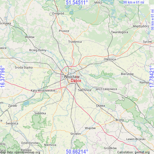
Dąbie GPS coordinates[2]
51° 6' 20.628" North, 17° 4' 51.888" East
| Map corner | latitude | longitude |
|---|---|---|
| Upper-left | 51.54511°, | 16.37796° |
| Center: | 51.10573°, | 17.08108° |
| Lower-right: | 50.66214°, | 17.78421° |
| Map W x H: | 98.2×98.2 km | = 61×61mi |
| max Lat: | 54.83135° ⇑52.4% North |
| Dąbie: | 51.10573° |
| min Lat: | ⇓47.6% South 49.21328° |
| min Long | Dąbie | max Long |
| 14.20249° | 17.08108° | 24.03723° |
| W 16.5%⇐ | ⇒83.5% E |
Elevation
Elevation of Dąbie is 121 m = 397 ft, and this is 70.4 m = 231 ft below average elevation for this country.
| Max E: |
974 m = 3196 ft | 69.8% |
| Avg. | 191.4 m = 628 ft | |
| Dąbie | 121 m = 397 ft | |
Min E: |
-3 m = -10 ft | 30.2% |
See also: Poland elevation on elevation.city.
Geographical zone
Dąbie is located in North temperate zone (between Tropic of Cancer and the Arctic Circle). Distance of this North polar circle is 1718.7 km =1068 mi to North.| Distance of | km | miles | from Dąbie |
|---|---|---|---|
| North Pole | 4324.6 | 2687.2 | to North |
| Arctic Circle | 1718.7 | 1068 | to North |
| Tropic Cancer | 3076.5 | 1911.6 | to South |
| Equator | 5682.4 | 3530.9 | to South |


Nearby cities:
15 places around Dąbie: (largest is in red/bold)
• Biskupin
1.7 km =1.1 mi,  107°
107°
• Kowale-Popiele
3.1 km =1.9 mi,  27°
27°
• Księże Małe-Księże Wielkie
3.7 km =2.3 mi,  171°
171°
• Osiedle Henrykowskie
2.6 km =1.6 mi,  228°
228°
• Rakowiec-Opatowice
2.4 km =1.5 mi,  139°
139°
• Rejon alei Kromera
3.2 km =2 mi,  347°
347°
• Rejon placu Grunwaldzkiego
1.8 km =1.1 mi,  311°
311°
• Rejon placu Świętego Macieja
3.5 km =2.2 mi,  298°
298°
• Rejon ulicy Traugutta
2.3 km =1.4 mi,  261°
261°
• Swojczyce
3.3 km =2.1 mi,  70°
70°
• Szczytniki
0.9 km =0.6 mi, 354°
• Sępolno
1.5 km =0.9 mi, 72°
• Wrocław
3.4 km =2.1 mi, 259°
• Zacisze
2 km =1.2 mi, 346°
• Zalesie i Stadion
1.7 km =1.1 mi, 26°
Sources, notices
• [Note1] Compared only with cities in Poland existing in our database
• [Src1] Map data: © OpenStreetMap contributors (CC-BY-SA)
• [Src2] Other city data from geonames.org with taken over terms of usage.
• [Src3] Geographical zone / Annual Mean Temperature by Robert A. Rohde @ Wikipedia
