Ściejowice geodata
Ściejowice (Lesser Poland) is a populated place; located in Poland in Europe/Warsaw (GMT+2) time zone. With population of 815 people, there are 2831 cities with bigger population in this country. Compared to other cities in Poland, 82.3% of cities are located further ↑North; 54.4% of cities are located further ←West and 65.9% of cities have lower elevation than Ściejowice. Note1


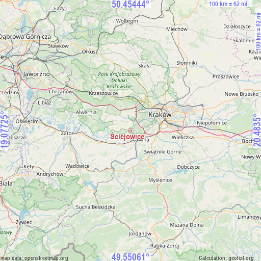
Ściejowice GPS coordinates[2]
50° 0' 16.74" North, 19° 46' 49.332" East
| Map corner | latitude | longitude |
|---|---|---|
| Upper-left | 50.45444°, | 19.07725° |
| Center: | 50.00465°, | 19.78037° |
| Lower-right: | 49.55061°, | 20.4835° |
| Map W x H: | 100.5×100.5 km | = 62.4×62.4mi |
| max Lat: | 54.83135° ⇑82.3% North |
| Ściejowice: | 50.00465° |
| min Lat: | ⇓17.7% South 49.21328° |
| min Long | Ściejowice | max Long |
| 14.20249° | 19.78037° | 24.03723° |
| W 54.4%⇐ | ⇒45.6% E |
Elevation
Elevation of Ściejowice is 216 m = 709 ft, and this is 24.6 m = 81 ft above average elevation for this country.
| Max E: |
974 m = 3196 ft | 34.1% |
| Ściejowice | 216 m 709 ft | |
| Avg. | 191.4 m = 628 ft | |
Min E: |
-3 m = -10 ft | 65.9% |
See also: Poland elevation on elevation.city.
Geographical zone
Ściejowice is located in North temperate zone (between Tropic of Cancer and the Arctic Circle). Distance of this North polar circle is 1841.2 km =1144.1 mi to North.| Distance of | km | miles | from Ściejowice |
|---|---|---|---|
| North Pole | 4447.1 | 2763.3 | to North |
| Arctic Circle | 1841.2 | 1144.1 | to North |
| Tropic Cancer | 2954.1 | 1835.6 | to South |
| Equator | 5560 | 3454.8 | to South |


Nearby cities:
15 places around Ściejowice: (largest is in red/bold)
• Borek Szlachecki
4.5 km =2.8 mi,  184°
184°
• Cholerzyn
6.2 km =3.9 mi,  349°
349°
• Facimiech
6 km =3.7 mi,  225°
225°
• Jeziorzany
1.2 km =0.7 mi,  195°
195°
• Kaszów
5.8 km =3.6 mi,  311°
311°
• Kopanka
2.5 km =1.6 mi,  158°
158°
• Kryspinów
4.5 km =2.8 mi,  16°
16°
• Liszki
3.9 km =2.4 mi, 347°
• Nowa Wieś Szlachecka
6.4 km =4 mi,  292°
292°
• Ochodza
5.1 km =3.2 mi,  211°
211°
• Piekary
2.5 km =1.6 mi,  26°
26°
• Rzozów
5.8 km =3.6 mi,  168°
168°
• Rączna
1.1 km =0.7 mi,  302°
302°
• Skawina
4.8 km =3 mi,  133°
133°
• Wołowice
4.2 km =2.6 mi,  245°
245°
Sources, notices
• [Note1] Compared only with cities in Poland existing in our database
• [Src1] Map data: © OpenStreetMap contributors (CC-BY-SA)
• [Src2] Other city data from geonames.org with taken over terms of usage.
• [Src3] Geographical zone / Annual Mean Temperature by Robert A. Rohde @ Wikipedia
