Rzozów geodata
Rzozów (Lesser Poland) is a populated place; located in Poland in Europe/Warsaw (GMT+2) time zone. With population of 1,600 people, there are 1751 cities with bigger population in this country. Compared to other cities in Poland, 85.2% of cities are located further ↑North; 54.8% of cities are located further ←West and 72.7% of cities have lower elevation than Rzozów. Note1


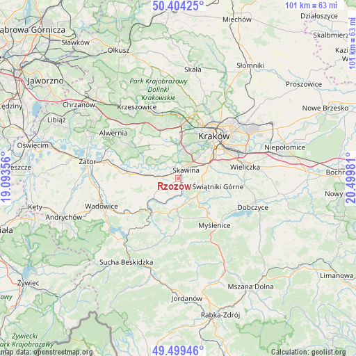
Rzozów GPS coordinates[2]
49° 57' 14.328" North, 19° 47' 48.048" East
| Map corner | latitude | longitude |
|---|---|---|
| Upper-left | 50.40425°, | 19.09356° |
| Center: | 49.95398°, | 19.79668° |
| Lower-right: | 49.49946°, | 20.49981° |
| Map W x H: | 100.6×100.6 km | = 62.5×62.5mi |
| max Lat: | 54.83135° ⇑85.2% North |
| Rzozów: | 49.95398° |
| min Lat: | ⇓14.8% South 49.21328° |
| min Long | Rzozów | max Long |
| 14.20249° | 19.79668° | 24.03723° |
| W 54.8%⇐ | ⇒45.2% E |
Elevation
Elevation of Rzozów is 238 m = 781 ft, and this is 46.6 m = 153 ft above average elevation for this country.
| Max E: |
974 m = 3196 ft | 27.3% |
| Rzozów | 238 m 781 ft | |
| Avg. | 191.4 m = 628 ft | |
Min E: |
-3 m = -10 ft | 72.7% |
See also: Poland elevation on elevation.city.
Geographical zone
Rzozów is located in North temperate zone (between Tropic of Cancer and the Arctic Circle). Distance of this North polar circle is 1846.8 km =1147.5 mi to North.| Distance of | km | miles | from Rzozów |
|---|---|---|---|
| North Pole | 4452.7 | 2766.8 | to North |
| Arctic Circle | 1846.8 | 1147.5 | to North |
| Tropic Cancer | 2948.4 | 1832.1 | to South |
| Equator | 5554.4 | 3451.3 | to South |


Nearby cities:
15 places around Rzozów: (largest is in red/bold)
• Borek Szlachecki
1.9 km =1.2 mi,  308°
308°
• Buków
3.6 km =2.2 mi,  104°
104°
• Facimiech
5.7 km =3.5 mi,  284°
284°
• Jeziorzany
4.8 km =3 mi,  341°
341°
• Kopanka
3.3 km =2.1 mi,  355°
355°
• Krzęcin
4.1 km =2.5 mi,  253°
253°
• Ochodza
4 km =2.5 mi,  288°
288°
• Radziszów
2.5 km =1.6 mi,  147°
147°
• Rączna
6.5 km =4 mi, 341°
• Sidzina
6.7 km =4.2 mi,  56°
56°
• Skawina
3.3 km =2.1 mi,  44°
44°
• Sosnowice
6 km =3.7 mi,  255°
255°
• Wola Radziszowska
5.4 km =3.4 mi,  186°
186°
• Wołowice
6.3 km =3.9 mi, 307°
• Ściejowice
5.8 km =3.6 mi,  348°
348°
Sources, notices
• [Note1] Compared only with cities in Poland existing in our database
• [Src1] Map data: © OpenStreetMap contributors (CC-BY-SA)
• [Src2] Other city data from geonames.org with taken over terms of usage.
• [Src3] Geographical zone / Annual Mean Temperature by Robert A. Rohde @ Wikipedia
