Puszczykowo geodata
Puszczykowo (Greater Poland) is a seat of a third-order administrative division; located in Poland in Europe/Warsaw (GMT+2) time zone. With population of 9,143 people, there are 475 cities with bigger population in this country. Compared to other cities in Poland, 72.1% of cities are located further ↓South; 86.7% of cities are located further →East and 89.9% of cities have higher elevation than Puszczykowo. Note1


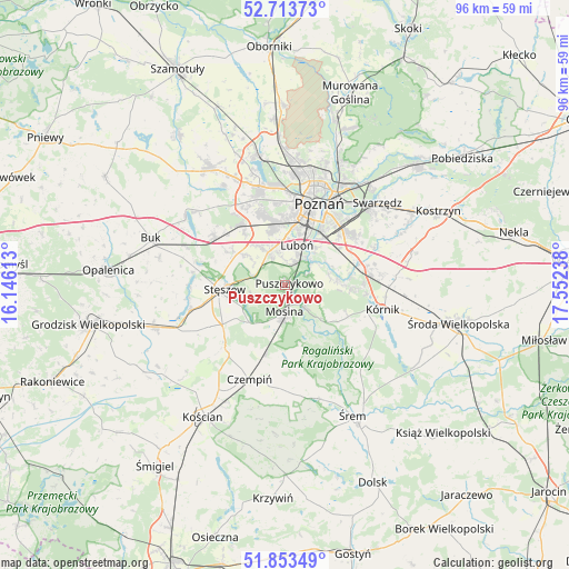
Puszczykowo GPS coordinates[2]
52° 17' 8.52" North, 16° 50' 57.3" East
| Map corner | latitude | longitude |
|---|---|---|
| Upper-left | 52.71373°, | 16.14613° |
| Center: | 52.2857°, | 16.84925° |
| Lower-right: | 51.85349°, | 17.55238° |
| Map W x H: | 95.6×95.6 km | = 59.4×59.4mi |
| max Lat: | 54.83135° ⇑27.9% North |
| Puszczykowo: | 52.2857° |
| min Lat: | ⇓72.1% South 49.21328° |
| min Long | Puszczykowo | max Long |
| 14.20249° | 16.84925° | 24.03723° |
| W 13.3%⇐ | ⇒86.7% E |
Elevation
Elevation of Puszczykowo is 76 m = 249 ft, and this is 115.4 m = 379 ft below average elevation for this country.
| Max E: |
974 m = 3196 ft | 89.9% |
| Avg. | 191.4 m = 628 ft | |
| Puszczykowo | 76 m = 249 ft | |
Min E: |
-3 m = -10 ft | 10.1% |
See also: Poland elevation on elevation.city.
Geographical zone
Puszczykowo is located in North temperate zone (between Tropic of Cancer and the Arctic Circle). Distance of this North polar circle is 1587.5 km =986.4 mi to North.| Distance of | km | miles | from Puszczykowo |
|---|---|---|---|
| North Pole | 4193.4 | 2605.7 | to North |
| Arctic Circle | 1587.5 | 986.4 | to North |
| Tropic Cancer | 3207.7 | 1993.2 | to South |
| Equator | 5813.6 | 3612.4 | to South |


Nearby cities:
15 places around Puszczykowo: (largest is in red/bold)
• Czapury
5.6 km =3.5 mi,  50°
50°
• Daszewice
7.5 km =4.7 mi,  77°
77°
• Gądki
13.8 km =8.6 mi, 77°
• Komorniki
6.5 km =4 mi,  335°
335°
• Krosinko
6.2 km =3.9 mi,  202°
202°
• Krosno
7 km =4.3 mi,  189°
189°
• Luboń
7.4 km =4.6 mi,  23°
23°
• Mosina
4.5 km =2.8 mi,  181°
181°
• Pecna
11.9 km =7.4 mi, 196°
• Plewiska
9.4 km =5.8 mi, 343°
• Rogalin
8.2 km =5.1 mi,  133°
133°
• Rogalinek
5.3 km =3.3 mi,  139°
139°
• Stęszew
10.1 km =6.3 mi,  268°
268°
• Wiórek
4.5 km =2.8 mi,  62°
62°
• Łęczyca
3 km =1.9 mi,  35°
35°
Sources, notices
• [Note1] Compared only with cities in Poland existing in our database
• [Src1] Map data: © OpenStreetMap contributors (CC-BY-SA)
• [Src2] Other city data from geonames.org with taken over terms of usage.
• [Src3] Geographical zone / Annual Mean Temperature by Robert A. Rohde @ Wikipedia
