Czapury geodata
Czapury (Greater Poland) is a populated place; located in Poland in Europe/Warsaw (GMT+2) time zone. With population of 1,256 people, there are 2120 cities with bigger population in this country. Compared to other cities in Poland, 73% of cities are located further ↓South; 85.8% of cities are located further →East and 92.9% of cities have higher elevation than Czapury. Note1


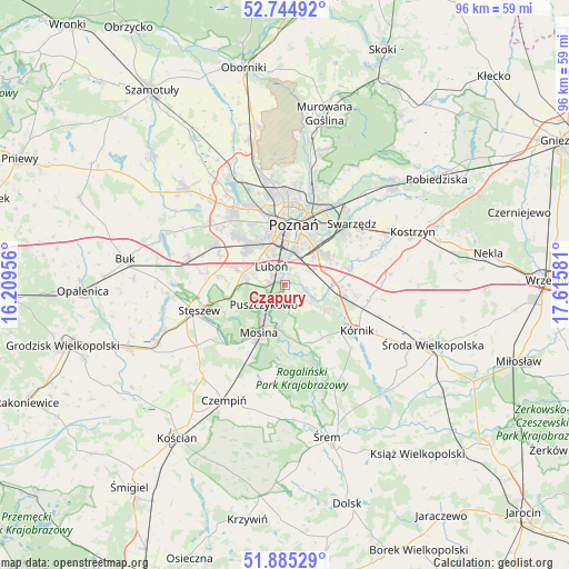
Czapury GPS coordinates[2]
52° 19' 1.884" North, 16° 54' 45.648" East
| Map corner | latitude | longitude |
|---|---|---|
| Upper-left | 52.74492°, | 16.20956° |
| Center: | 52.31719°, | 16.91268° |
| Lower-right: | 51.88529°, | 17.61581° |
| Map W x H: | 95.6×95.6 km | = 59.4×59.4mi |
| max Lat: | 54.83135° ⇑27% North |
| Czapury: | 52.31719° |
| min Lat: | ⇓73% South 49.21328° |
| min Long | Czapury | max Long |
| 14.20249° | 16.91268° | 24.03723° |
| W 14.2%⇐ | ⇒85.8% E |
Elevation
Elevation of Czapury is 60 m = 197 ft, and this is 131.4 m = 431 ft below average elevation for this country.
| Max E: |
974 m = 3196 ft | 92.9% |
| Avg. | 191.4 m = 628 ft | |
| Czapury | 60 m = 197 ft | |
Min E: |
-3 m = -10 ft | 7.1% |
See also: Poland elevation on elevation.city.
Geographical zone
Czapury is located in North temperate zone (between Tropic of Cancer and the Arctic Circle). Distance of this North polar circle is 1584 km =984.3 mi to North.| Distance of | km | miles | from Czapury |
|---|---|---|---|
| North Pole | 4189.9 | 2603.5 | to North |
| Arctic Circle | 1584 | 984.3 | to North |
| Tropic Cancer | 3211.2 | 1995.3 | to South |
| Equator | 5817.1 | 3614.6 | to South |


Nearby cities:
15 places around Czapury: (largest is in red/bold)
• Daszewice
3.6 km =2.2 mi,  122°
122°
• Gądki
9.1 km =5.7 mi,  93°
93°
• Komorniki
7.3 km =4.5 mi,  289°
289°
• Krosinko
11.4 km =7.1 mi,  216°
216°
• Krosno
11.8 km =7.3 mi,  207°
207°
• Kórnik
14.3 km =8.9 mi, 122°
• Luboń
3.6 km =2.2 mi,  337°
337°
• Mosina
9.1 km =5.7 mi, 209°
• Plewiska
8.9 km =5.5 mi,  308°
308°
• Poznań
10 km =6.2 mi,  6°
6°
• Puszczykowo
5.6 km =3.5 mi,  230°
230°
• Rogalin
9.3 km =5.8 mi,  169°
169°
• Rogalinek
7.6 km =4.7 mi,  186°
186°
• Wiórek
1.5 km =0.9 mi, 192°
• Łęczyca
2.7 km =1.7 mi,  248°
248°
Sources, notices
• [Note1] Compared only with cities in Poland existing in our database
• [Src1] Map data: © OpenStreetMap contributors (CC-BY-SA)
• [Src2] Other city data from geonames.org with taken over terms of usage.
• [Src3] Geographical zone / Annual Mean Temperature by Robert A. Rohde @ Wikipedia
