Komorniki geodata
Komorniki (Greater Poland) is a seat of a third-order administrative division; located in Poland in Europe/Warsaw (GMT+2) time zone. With population of 5,144 people, there are 672 cities with bigger population in this country. Compared to other cities in Poland, 73.4% of cities are located further ↓South; 87.2% of cities are located further →East and 88.9% of cities have higher elevation than Komorniki. Note1


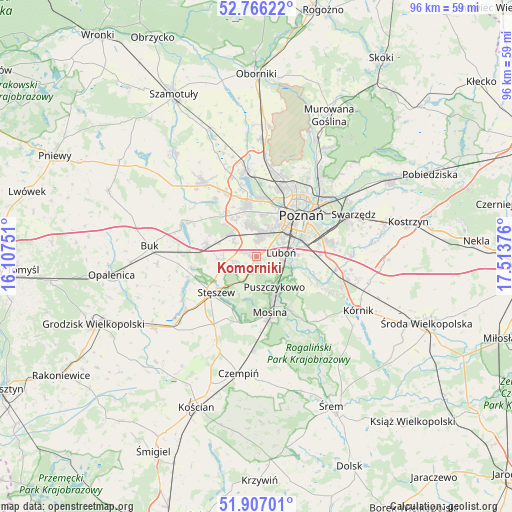
Komorniki GPS coordinates[2]
52° 20' 19.32" North, 16° 48' 38.268" East
| Map corner | latitude | longitude |
|---|---|---|
| Upper-left | 52.76622°, | 16.10751° |
| Center: | 52.3387°, | 16.81063° |
| Lower-right: | 51.90701°, | 17.51376° |
| Map W x H: | 95.5×95.5 km | = 59.3×59.3mi |
| max Lat: | 54.83135° ⇑26.6% North |
| Komorniki: | 52.3387° |
| min Lat: | ⇓73.4% South 49.21328° |
| min Long | Komorniki | max Long |
| 14.20249° | 16.81063° | 24.03723° |
| W 12.8%⇐ | ⇒87.2% E |
Elevation
Elevation of Komorniki is 79 m = 259 ft, and this is 112.4 m = 369 ft below average elevation for this country.
| Max E: |
974 m = 3196 ft | 88.9% |
| Avg. | 191.4 m = 628 ft | |
| Komorniki | 79 m = 259 ft | |
Min E: |
-3 m = -10 ft | 11.1% |
See also: Poland elevation on elevation.city.
Geographical zone
Komorniki is located in North temperate zone (between Tropic of Cancer and the Arctic Circle). Distance of this North polar circle is 1581.7 km =982.8 mi to North.| Distance of | km | miles | from Komorniki |
|---|---|---|---|
| North Pole | 4187.5 | 2602 | to North |
| Arctic Circle | 1581.7 | 982.8 | to North |
| Tropic Cancer | 3213.6 | 1996.8 | to South |
| Equator | 5819.5 | 3616.1 | to South |


Nearby cities:
15 places around Komorniki: (largest is in red/bold)
• Baranowo
10.9 km =6.8 mi,  351°
351°
• Czapury
7.3 km =4.5 mi,  109°
109°
• Daszewice
10.9 km =6.8 mi, 113°
• Dopiewo
9.4 km =5.8 mi,  282°
282°
• Krosinko
11.6 km =7.2 mi,  178°
178°
• Luboń
5.6 km =3.5 mi,  80°
80°
• Mosina
10.7 km =6.6 mi,  166°
166°
• Plewiska
3.2 km =2 mi,  359°
359°
• Poznań
11.1 km =6.9 mi,  46°
46°
• Puszczykowo
6.5 km =4 mi,  155°
155°
• Rogalinek
11.6 km =7.2 mi,  148°
148°
• Stęszew
9.6 km =6 mi,  230°
230°
• Wiórek
7.6 km =4.7 mi,  119°
119°
• Zakrzewo
8.4 km =5.2 mi,  316°
316°
• Łęczyca
5.6 km =3.5 mi,  127°
127°
Sources, notices
• [Note1] Compared only with cities in Poland existing in our database
• [Src1] Map data: © OpenStreetMap contributors (CC-BY-SA)
• [Src2] Other city data from geonames.org with taken over terms of usage.
• [Src3] Geographical zone / Annual Mean Temperature by Robert A. Rohde @ Wikipedia
