Pisarzowice geodata
Pisarzowice (Silesia) is a populated place; located in Poland in Europe/Warsaw (GMT+2) time zone. With population of 4,673 people, there are 719 cities with bigger population in this country. Compared to other cities in Poland, 88.2% of cities are located further ↑North; 57.3% of cities are located further →East and 85.9% of cities have lower elevation than Pisarzowice. Note1


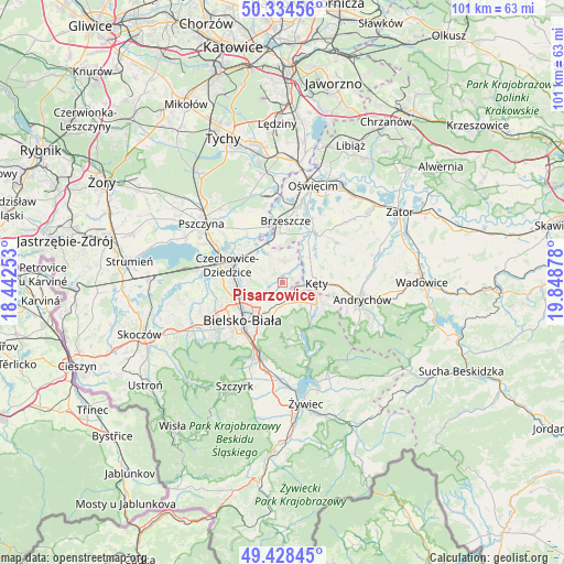
Pisarzowice GPS coordinates[2]
49° 53' 1.068" North, 19° 8' 44.34" East
| Map corner | latitude | longitude |
|---|---|---|
| Upper-left | 50.33456°, | 18.44253° |
| Center: | 49.88363°, | 19.14565° |
| Lower-right: | 49.42845°, | 19.84878° |
| Map W x H: | 100.7×100.7 km | = 62.6×62.6mi |
| max Lat: | 54.83135° ⇑88.2% North |
| Pisarzowice: | 49.88363° |
| min Lat: | ⇓11.8% South 49.21328° |
| min Long | Pisarzowice | max Long |
| 14.20249° | 19.14565° | 24.03723° |
| W 42.7%⇐ | ⇒57.3% E |
Elevation
Elevation of Pisarzowice is 295 m = 968 ft, and this is 103.6 m = 340 ft above average elevation for this country.
| Max E: |
974 m = 3196 ft | 14.1% |
| Pisarzowice | 295 m 968 ft | |
| Avg. | 191.4 m = 628 ft | |
Min E: |
-3 m = -10 ft | 85.9% |
See also: Poland elevation on elevation.city.
Geographical zone
Pisarzowice is located in North temperate zone (between Tropic of Cancer and the Arctic Circle). Distance of this North polar circle is 1854.6 km =1152.4 mi to North.| Distance of | km | miles | from Pisarzowice |
|---|---|---|---|
| North Pole | 4460.5 | 2771.6 | to North |
| Arctic Circle | 1854.6 | 1152.4 | to North |
| Tropic Cancer | 2940.6 | 1827.2 | to South |
| Equator | 5546.5 | 3446.4 | to South |


Nearby cities:
15 places around Pisarzowice: (largest is in red/bold)
• Bestwina
6.5 km =4 mi,  283°
283°
• Bestwinka
7.8 km =4.8 mi,  314°
314°
• Bielsko-Biala
9.8 km =6.1 mi,  226°
226°
• Bujaków
5 km =3.1 mi,  135°
135°
• Czaniec
8.6 km =5.3 mi,  115°
115°
• Janowice
3.7 km =2.3 mi,  272°
272°
• Kaniów
9.5 km =5.9 mi, 314°
• Kobiernice
6 km =3.7 mi, 122°
• Kozy
4 km =2.5 mi,  176°
176°
• Kęty
5.6 km =3.5 mi,  91°
91°
• Malec
8.3 km =5.2 mi,  59°
59°
• Nowa Wieś
5.7 km =3.5 mi, 62°
• Porąbka
9 km =5.6 mi, 144°
• Wilamowice
3.7 km =2.3 mi,  7°
7°
• Witkowice
10 km =6.2 mi,  74°
74°
Sources, notices
• [Note1] Compared only with cities in Poland existing in our database
• [Src1] Map data: © OpenStreetMap contributors (CC-BY-SA)
• [Src2] Other city data from geonames.org with taken over terms of usage.
• [Src3] Geographical zone / Annual Mean Temperature by Robert A. Rohde @ Wikipedia
