Wilamowice geodata
Wilamowice (Silesia) is a populated place; located in Poland in Europe/Warsaw (GMT+2) time zone. With population of 2,813 people, there are 1113 cities with bigger population in this country. Compared to other cities in Poland, 86.8% of cities are located further ↑North; 57.1% of cities are located further →East and 83.7% of cities have lower elevation than Wilamowice. Note1


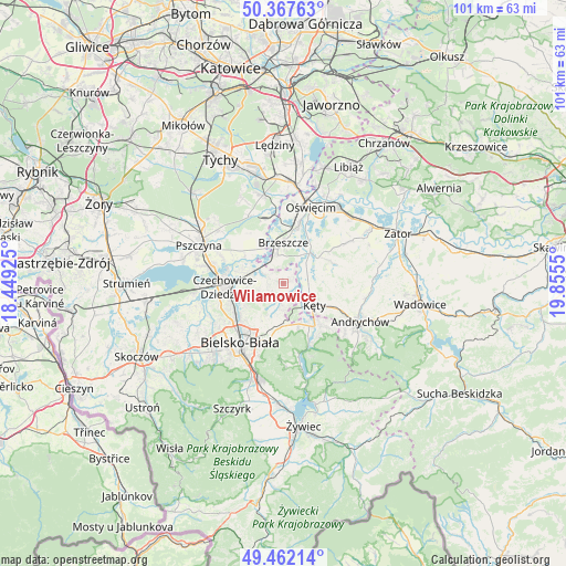
Wilamowice GPS coordinates[2]
49° 55' 1.236" North, 19° 9' 8.532" East
| Map corner | latitude | longitude |
|---|---|---|
| Upper-left | 50.36763°, | 18.44925° |
| Center: | 49.91701°, | 19.15237° |
| Lower-right: | 49.46214°, | 19.8555° |
| Map W x H: | 100.7×100.7 km | = 62.6×62.6mi |
| max Lat: | 54.83135° ⇑86.8% North |
| Wilamowice: | 49.91701° |
| min Lat: | ⇓13.2% South 49.21328° |
| min Long | Wilamowice | max Long |
| 14.20249° | 19.15237° | 24.03723° |
| W 42.9%⇐ | ⇒57.1% E |
Elevation
Elevation of Wilamowice is 284 m = 932 ft, and this is 92.6 m = 304 ft above average elevation for this country.
| Max E: |
974 m = 3196 ft | 16.3% |
| Wilamowice | 284 m 932 ft | |
| Avg. | 191.4 m = 628 ft | |
Min E: |
-3 m = -10 ft | 83.7% |
See also: Poland elevation on elevation.city.
Geographical zone
Wilamowice is located in North temperate zone (between Tropic of Cancer and the Arctic Circle). Distance of this North polar circle is 1850.9 km =1150.1 mi to North.| Distance of | km | miles | from Wilamowice |
|---|---|---|---|
| North Pole | 4456.8 | 2769.3 | to North |
| Arctic Circle | 1850.9 | 1150.1 | to North |
| Tropic Cancer | 2944.3 | 1829.5 | to South |
| Equator | 5550.3 | 3448.8 | to South |


Nearby cities:
15 places around Wilamowice: (largest is in red/bold)
• Bestwina
7.1 km =4.4 mi,  251°
251°
• Bestwinka
6.4 km =4 mi,  285°
285°
• Brzeszcze
7.2 km =4.5 mi,  359°
359°
• Bujaków
7.8 km =4.8 mi,  157°
157°
• Góra
7.8 km =4.8 mi,  333°
333°
• Janowice
5.5 km =3.4 mi,  229°
229°
• Kaniów
7.8 km =4.8 mi, 291°
• Kobiernice
8.3 km =5.2 mi,  146°
146°
• Kozy
7.7 km =4.8 mi,  181°
181°
• Kęty
6.4 km =4 mi,  127°
127°
• Malec
6.7 km =4.2 mi,  86°
86°
• Nowa Wieś
4.7 km =2.9 mi,  103°
103°
• Pisarzowice
3.7 km =2.3 mi,  187°
187°
• Przecieszyn
6.9 km =4.3 mi,  10°
10°
• Skidziń
7.7 km =4.8 mi,  25°
25°
Sources, notices
• [Note1] Compared only with cities in Poland existing in our database
• [Src1] Map data: © OpenStreetMap contributors (CC-BY-SA)
• [Src2] Other city data from geonames.org with taken over terms of usage.
• [Src3] Geographical zone / Annual Mean Temperature by Robert A. Rohde @ Wikipedia
