Bestwinka geodata
Bestwinka (Silesia) is a populated place; located in Poland in Europe/Warsaw (GMT+2) time zone. With population of 1,541 people, there are 1811 cities with bigger population in this country. Compared to other cities in Poland, 86.4% of cities are located further ↑North; 58.9% of cities are located further →East and 74.8% of cities have lower elevation than Bestwinka. Note1


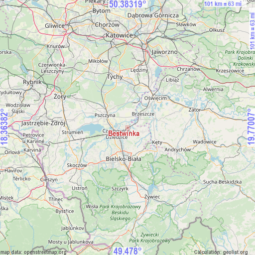
Bestwinka GPS coordinates[2]
49° 55' 57.792" North, 19° 4' 0.984" East
| Map corner | latitude | longitude |
|---|---|---|
| Upper-left | 50.38319°, | 18.36382° |
| Center: | 49.93272°, | 19.06694° |
| Lower-right: | 49.478°, | 19.77007° |
| Map W x H: | 100.6×100.6 km | = 62.5×62.5mi |
| max Lat: | 54.83135° ⇑86.4% North |
| Bestwinka: | 49.93272° |
| min Lat: | ⇓13.6% South 49.21328° |
| min Long | Bestwinka | max Long |
| 14.20249° | 19.06694° | 24.03723° |
| W 41.1%⇐ | ⇒58.9% E |
Elevation
Elevation of Bestwinka is 246 m = 807 ft, and this is 54.6 m = 179 ft above average elevation for this country.
| Max E: |
974 m = 3196 ft | 25.2% |
| Bestwinka | 246 m 807 ft | |
| Avg. | 191.4 m = 628 ft | |
Min E: |
-3 m = -10 ft | 74.8% |
See also: Poland elevation on elevation.city.
Geographical zone
Bestwinka is located in North temperate zone (between Tropic of Cancer and the Arctic Circle). Distance of this North polar circle is 1849.2 km =1149 mi to North.| Distance of | km | miles | from Bestwinka |
|---|---|---|---|
| North Pole | 4455.1 | 2768.3 | to North |
| Arctic Circle | 1849.2 | 1149 | to North |
| Tropic Cancer | 2946.1 | 1830.6 | to South |
| Equator | 5552 | 3449.9 | to South |


Nearby cities:
15 places around Bestwinka: (largest is in red/bold)
• Bestwina
4 km =2.5 mi,  189°
189°
• Brzeszcze
8.2 km =5.1 mi,  47°
47°
• Czechowice-Dziedzice
4.9 km =3 mi,  244°
244°
• Frydek
7.1 km =4.4 mi,  3°
3°
• Gilowice
7.2 km =4.5 mi,  16°
16°
• Goczałkowice Zdrój
7.1 km =4.4 mi,  280°
280°
• Góra
5.9 km =3.7 mi,  27°
27°
• Janowice
5.6 km =3.5 mi,  160°
160°
• Kaniów
1.6 km =1 mi,  315°
315°
• Ligota
9.1 km =5.7 mi,  245°
245°
• Miedźna
5.7 km =3.5 mi,  346°
346°
• Pisarzowice
7.8 km =4.8 mi,  134°
134°
• Przecieszyn
9 km =5.6 mi,  55°
55°
• Wilamowice
6.4 km =4 mi,  105°
105°
• Zabrzeg
9.1 km =5.7 mi,  258°
258°
Sources, notices
• [Note1] Compared only with cities in Poland existing in our database
• [Src1] Map data: © OpenStreetMap contributors (CC-BY-SA)
• [Src2] Other city data from geonames.org with taken over terms of usage.
• [Src3] Geographical zone / Annual Mean Temperature by Robert A. Rohde @ Wikipedia
