Istebna geodata
Istebna (Silesia) is a populated place; located in Poland in Europe/Warsaw (GMT+2) time zone. With population of 4,895 people, there are 698 cities with bigger population in this country. Compared to other cities in Poland, 97.4% of cities are located further ↑North; 61.8% of cities are located further →East and 98.9% of cities have lower elevation than Istebna. Note1


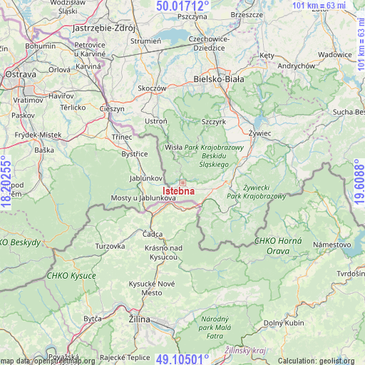
Istebna GPS coordinates[2]
49° 33' 47.484" North, 18° 54' 20.412" East
| Map corner | latitude | longitude |
|---|---|---|
| Upper-left | 50.01712°, | 18.20255° |
| Center: | 49.56319°, | 18.90567° |
| Lower-right: | 49.10501°, | 19.6088° |
| Map W x H: | 101.4×101.4 km | = 63×63mi |
| max Lat: | 54.83135° ⇑97.4% North |
| Istebna: | 49.56319° |
| min Lat: | ⇓2.6% South 49.21328° |
| min Long | Istebna | max Long |
| 14.20249° | 18.90567° | 24.03723° |
| W 38.2%⇐ | ⇒61.8% E |
Elevation
Elevation of Istebna is 617 m = 2024 ft, and this is 425.6 m = 1396 ft above average elevation for this country.
| Max E: |
974 m = 3196 ft | 1.1% |
| Istebna | 617 m 2024 ft | |
| Avg. | 191.4 m = 628 ft | |
Min E: |
-3 m = -10 ft | 98.9% |
See also: Poland elevation on elevation.city.
Geographical zone
Istebna is located in North temperate zone (between Tropic of Cancer and the Arctic Circle). Distance of this North polar circle is 1890.3 km =1174.6 mi to North.| Distance of | km | miles | from Istebna |
|---|---|---|---|
| North Pole | 4496.2 | 2793.8 | to North |
| Arctic Circle | 1890.3 | 1174.6 | to North |
| Tropic Cancer | 2905 | 1805.1 | to South |
| Equator | 5510.9 | 3424.3 | to South |


Nearby cities:
15 places around Istebna: (largest is in red/bold)
• Cisiec
14.8 km =9.2 mi,  77°
77°
• Cięcina
17.5 km =10.9 mi, 75°
• Jaworzynka
3.6 km =2.2 mi,  225°
225°
• Kamesznica
8.3 km =5.2 mi,  88°
88°
• Koniaków
3.4 km =2.1 mi,  113°
113°
• Laliki
7.9 km =4.9 mi, 113°
• Milówka
13.4 km =8.3 mi, 93°
• Przybędza
17.5 km =10.9 mi,  64°
64°
• Rajcza
16.1 km =10 mi, 111°
• Rycerka Dolna
14.7 km =9.1 mi,  130°
130°
• Rycerka Górna
15.4 km =9.6 mi,  148°
148°
• Sól
12.9 km =8 mi, 130°
• Wisła
10.9 km =6.8 mi,  342°
342°
• Węgierska Górka
16 km =9.9 mi,  71°
71°
• Zwardoń
8.3 km =5.2 mi,  142°
142°
Sources, notices
• [Note1] Compared only with cities in Poland existing in our database
• [Src1] Map data: © OpenStreetMap contributors (CC-BY-SA)
• [Src2] Other city data from geonames.org with taken over terms of usage.
• [Src3] Geographical zone / Annual Mean Temperature by Robert A. Rohde @ Wikipedia
