Rycerka Górna geodata
Rycerka Górna (Silesia) is a populated place; located in Poland in Europe/Warsaw (GMT+2) time zone. With population of 1,602 people, there are 1748 cities with bigger population in this country. Compared to other cities in Poland, 99.2% of cities are located further ↑North; 59.8% of cities are located further →East and 99.3% of cities have lower elevation than Rycerka Górna. Note1


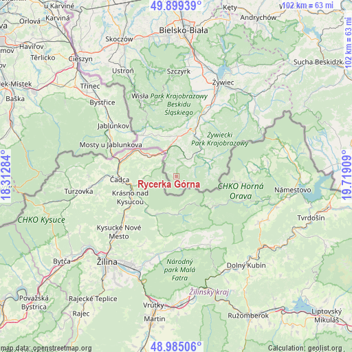
Rycerka Górna GPS coordinates[2]
49° 26' 39.696" North, 19° 0' 57.456" East
| Map corner | latitude | longitude |
|---|---|---|
| Upper-left | 49.89939°, | 18.31284° |
| Center: | 49.44436°, | 19.01596° |
| Lower-right: | 48.98506°, | 19.71909° |
| Map W x H: | 101.7×101.7 km | = 63.2×63.2mi |
| max Lat: | 54.83135° ⇑99.2% North |
| Rycerka Górna: | 49.44436° |
| min Lat: | ⇓0.8% South 49.21328° |
| min Long | Rycerka Górna | max Long |
| 14.20249° | 19.01596° | 24.03723° |
| W 40.2%⇐ | ⇒59.8% E |
Elevation
Elevation of Rycerka Górna is 661 m = 2169 ft, and this is 469.6 m = 1541 ft above average elevation for this country.
| Max E: |
974 m = 3196 ft | 0.7% |
| Rycerka Górna | 661 m 2169 ft | |
| Avg. | 191.4 m = 628 ft | |
Min E: |
-3 m = -10 ft | 99.3% |
See also: Poland elevation on elevation.city.
Geographical zone
Rycerka Górna is located in North temperate zone (between Tropic of Cancer and the Arctic Circle). Distance of this North polar circle is 1903.5 km =1182.8 mi to North.| Distance of | km | miles | from Rycerka Górna |
|---|---|---|---|
| North Pole | 4509.4 | 2802 | to North |
| Arctic Circle | 1903.5 | 1182.8 | to North |
| Tropic Cancer | 2891.8 | 1796.9 | to South |
| Equator | 5497.7 | 3416.1 | to South |


Nearby cities:
15 places around Rycerka Górna: (largest is in red/bold)
• Cisiec
17.7 km =11 mi,  21°
21°
• Glinka
10.8 km =6.7 mi,  79°
79°
• Istebna
15.4 km =9.6 mi,  328°
328°
• Jaworzynka
15 km =9.3 mi,  315°
315°
• Kamesznica
13.4 km =8.3 mi,  1°
1°
• Koniaków
12.8 km =8 mi,  337°
337°
• Laliki
10 km =6.2 mi,  355°
355°
• Milówka
13.5 km =8.4 mi, 23°
• Rajcza
10.1 km =6.3 mi,  44°
44°
• Rycerka Dolna
5 km =3.1 mi, 41°
• Soblówka
9.2 km =5.7 mi,  96°
96°
• Sól
5.2 km =3.2 mi, 21°
• Ujsoły
9.8 km =6.1 mi,  64°
64°
• Zwardoń
7.2 km =4.5 mi, 336°
• Żabnica
18.3 km =11.4 mi,  33°
33°
Sources, notices
• [Note1] Compared only with cities in Poland existing in our database
• [Src1] Map data: © OpenStreetMap contributors (CC-BY-SA)
• [Src2] Other city data from geonames.org with taken over terms of usage.
• [Src3] Geographical zone / Annual Mean Temperature by Robert A. Rohde @ Wikipedia
