Mayagüez geodata
Mayagüez is a seat of a first-order administrative division; located in Puerto Rico in America/Puerto_Rico (GMT-4) time zone. With population of 78,647 people, there are 6 cities with bigger population in this country. Compared to other cities in Puerto Rico, 56.9% of cities are located further ↑North; 95.1% of cities are located further →East and 65.3% of cities have higher elevation than Mayagüez. Note1


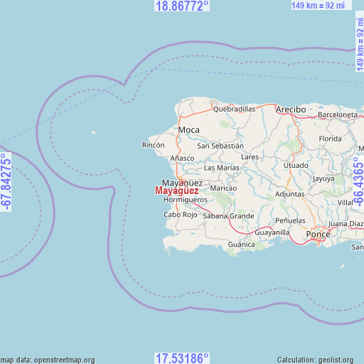
Mayagüez GPS coordinates[2]
18° 12' 3.852" North, 67° 8' 22.632" West
| Map corner | latitude | longitude |
|---|---|---|
| Upper-left | 18.86772°, | -67.84275° |
| Center: | 18.20107°, | -67.13962° |
| Lower-right: | 17.53186°, | -66.4365° |
| Map W x H: | 148.5×148.5 km | = 92.3×92.3mi |
| max Lat: | 18.50078° ⇑56.9% North |
| Mayagüez: | 18.20107° |
| min Lat: | ⇓43.1% South 17.95358° |
| min Long | Mayagüez | max Long |
| -67.2499° | -67.13962° | -65.30099° |
| W 4.9%⇐ | ⇒95.1% E |
Elevation
Elevation of Mayagüez is 27 m = 89 ft, and this is 73.5 m = 241 ft below average elevation for this country.
| Max E: |
655 m = 2149 ft | 65.3% |
| Avg. | 100.5 m = 330 ft | |
| Mayagüez | 27 m = 89 ft | |
Min E: |
1 m = 3 ft | 34.7% |
See also: Mayagüez elevation on elevation.city.
Geographical zone
Mayagüez is located in North Torrid zone (between Equator and Tropic of Cancer). Distance of this Northern Tropic circle is 582.1 km =361.7 mi to North.| Distance of | km | miles | from Mayagüez |
|---|---|---|---|
| North Pole | 7983.3 | 4960.6 | to North |
| Arctic Circle | 5377.4 | 3341.4 | to North |
| Tropic Cancer | 582.1 | 361.7 | to North |
| Equator | 2023.8 | 1257.5 | to South |


Nearby cities:
15 places around Mayagüez: (largest is in red/bold)
• Añasco
9.1 km =5.7 mi,  0°
0°
• Cabo Rojo
12.7 km =7.9 mi,  182°
182°
• Espino
8.6 km =5.3 mi,  14°
14°
• Hormigueros
6.9 km =4.3 mi,  169°
169°
• La Playa
10.8 km =6.7 mi,  332°
332°
• Lajas
18.8 km =11.7 mi,  153°
153°
• Las Marias
10.3 km =6.4 mi,  356°
356°
• Las Marías
16.6 km =10.3 mi,  70°
70°
• Luyando
18.3 km =11.4 mi,  354°
354°
• Maricao
17 km =10.6 mi,  97°
97°
• Monte Grande
13.1 km =8.1 mi,  164°
164°
• Puerto Real
14.9 km =9.3 mi,  199°
199°
• Sabana Eneas
14.2 km =8.8 mi, 154°
• San Germán
16.6 km =10.3 mi,  142°
142°
• Stella
17.6 km =10.9 mi,  319°
319°
Sources, notices
• [Note1] Compared only with cities in Puerto Rico existing in our database
• [Src1] Map data: © OpenStreetMap contributors (CC-BY-SA)
• [Src2] Other city data from geonames.org with taken over terms of usage.
• [Src3] Geographical zone / Annual Mean Temperature by Robert A. Rohde @ Wikipedia
