Añasco geodata
Añasco is a seat of a first-order administrative division; located in Puerto Rico in America/Puerto_Rico (GMT-4) time zone. With population of 6,136 people, there are 57 cities with bigger population in this country. Compared to other cities in Puerto Rico, 55.6% of cities are located further ↓South; 95.1% of cities are located further →East and 81.3% of cities have higher elevation than Añasco. Note1


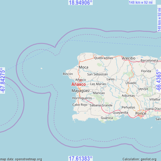
Añasco GPS coordinates[2]
18° 16' 57.828" North, 67° 8' 22.632" West
| Map corner | latitude | longitude |
|---|---|---|
| Upper-left | 18.94906°, | -67.84275° |
| Center: | 18.28273°, | -67.13962° |
| Lower-right: | 17.61383°, | -66.4365° |
| Map W x H: | 148.5×148.5 km | = 92.3×92.3mi |
| max Lat: | 18.50078° ⇑44.4% North |
| Añasco: | 18.28273° |
| min Lat: | ⇓55.6% South 17.95358° |
| min Long | Añasco | max Long |
| -67.2499° | -67.13962° | -65.30099° |
| W 4.9%⇐ | ⇒95.1% E |
Elevation
Elevation of Añasco is 14 m = 46 ft, and this is 86.5 m = 284 ft below average elevation for this country.
| Max E: |
655 m = 2149 ft | 81.3% |
| Avg. | 100.5 m = 330 ft | |
| Añasco | 14 m = 46 ft | |
Min E: |
1 m = 3 ft | 18.7% |
See also: Puerto Rico elevation on elevation.city.
Geographical zone
Añasco is located in North Torrid zone (between Equator and Tropic of Cancer). Distance of this Northern Tropic circle is 573.1 km =356.1 mi to North.| Distance of | km | miles | from Añasco |
|---|---|---|---|
| North Pole | 7974.2 | 4954.9 | to North |
| Arctic Circle | 5368.3 | 3335.7 | to North |
| Tropic Cancer | 573.1 | 356.1 | to North |
| Equator | 2032.8 | 1263.1 | to South |


Nearby cities:
15 places around Añasco: (largest is in red/bold)
• Aguada
11.9 km =7.4 mi,  334°
334°
• Aguadilla
16.2 km =10.1 mi,  354°
354°
• Caban
17.9 km =11.1 mi,  1°
1°
• Espino
2.3 km =1.4 mi,  108°
108°
• Hato Arriba
13.8 km =8.6 mi,  53°
53°
• Hormigueros
16 km =9.9 mi,  175°
175°
• La Playa
5 km =3.1 mi,  276°
276°
• Las Marias
1.4 km =0.9 mi, 329°
• Las Marías
15.9 km =9.9 mi,  102°
102°
• Luyando
9.3 km =5.8 mi, 348°
• Mayagüez
9.1 km =5.7 mi, 180°
• Moca
12.8 km =8 mi,  12°
12°
• Rincón
13.3 km =8.3 mi,  298°
298°
• San Sebastián
16.9 km =10.5 mi,  69°
69°
• Stella
12.1 km =7.5 mi,  291°
291°
Sources, notices
• [Note1] Compared only with cities in Puerto Rico existing in our database
• [Src1] Map data: © OpenStreetMap contributors (CC-BY-SA)
• [Src2] Other city data from geonames.org with taken over terms of usage.
• [Src3] Geographical zone / Annual Mean Temperature by Robert A. Rohde @ Wikipedia
