‘Arab ar Rashāydah geodata
‘Arab ar Rashāydah is a populated place; located in Palestinian Territory in Asia/Hebron (GMT+3) time zone. With population of 1,435 people, there are 285 cities with bigger population in this country. Compared to other cities in Palestinian Territory, 81.4% of cities are located further ↑North; 72.3% of cities are located further ←West and 65.4% of cities have lower elevation than ‘Arab ar Rashāydah. Note1


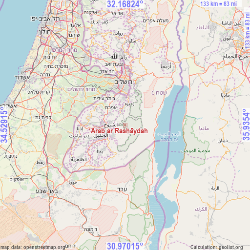
‘Arab ar Rashāydah GPS coordinates[2]
31° 34' 16.032" North, 35° 13' 56.172" East
| Map corner | latitude | longitude |
|---|---|---|
| Upper-left | 32.16824°, | 34.52915° |
| Center: | 31.57112°, | 35.23227° |
| Lower-right: | 30.97015°, | 35.9354° |
| Map W x H: | 133.2×133.2 km | = 82.8×82.8mi |
| max Lat: | 32.54346° ⇑81.4% North |
| ‘Arab ar Rashāydah: | 31.57112° |
| min Lat: | ⇓18.6% South 31.25997° |
| min Long | ‘Arab ar Rash | max Long |
| 34.24357° | 35.23227° | 35.53898° |
| W 72.3%⇐ | ⇒27.7% E |
Elevation
Elevation of ‘Arab ar Rashāydah is 599 m = 1965 ft, and this is 125.7 m = 412 ft above average elevation for this country.
| Max E: |
999 m = 3278 ft | 34.6% |
| ‘Arab ar Rashāydah | 599 m 1965 ft | |
| Avg. | 473.3 m = 1553 ft | |
Min E: |
-269 m = -883 ft | 65.4% |
See also: Palestinian Territory elevation on elevation.city.
Geographical zone
‘Arab ar Rashāydah is located in North temperate zone (between Tropic of Cancer and the Arctic Circle). Distance of this Northern Tropic circle is 904.5 km =562 mi to South.| Distance of | km | miles | from ‘Arab ar Rashāydah |
|---|---|---|---|
| North Pole | 6496.7 | 4036.9 | to North |
| Arctic Circle | 3890.8 | 2417.6 | to North |
| Tropic Cancer | 904.5 | 562 | to South |
| Equator | 3510.4 | 2181.3 | to South |


Nearby cities:
15 places around ‘Arab ar Rashāydah: (largest is in red/bold)
• Al Buq‘ah
9.1 km =5.7 mi,  249°
249°
• Al Manīyah
5.4 km =3.4 mi,  348°
348°
• Al Ma‘şarah
10.6 km =6.6 mi,  331°
331°
• Ash Shuyūkh
7.2 km =4.5 mi,  269°
269°
• Banī Na‘īm
8.9 km =5.5 mi,  226°
226°
• Bayt Fajjār
9.4 km =5.8 mi,  308°
308°
• Bayt ‘Īnūn
10.3 km =6.4 mi,  262°
262°
• Jannātah
11 km =6.8 mi, 353°
• Jūrat ash Sham‘ah
10.6 km =6.6 mi, 326°
• Marāḩ Ma‘allā
10.3 km =6.4 mi, 327°
• Marāḩ Rabbāḩ
8.2 km =5.1 mi, 328°
• Qilā‘ Zaytā
10.8 km =6.7 mi, 259°
• Sa‘īr
8.8 km =5.5 mi,  275°
275°
• Shuyūkh al ‘Arrūb
9.8 km =6.1 mi,  301°
301°
• Umm Salmūnah
10.3 km =6.4 mi,  322°
322°
Sources, notices
• [Note1] Compared only with cities in Palestinian Territory existing in our database
• [Src1] Map data: © OpenStreetMap contributors (CC-BY-SA)
• [Src2] Other city data from geonames.org with taken over terms of usage.
• [Src3] Geographical zone / Annual Mean Temperature by Robert A. Rohde @ Wikipedia
