Khashm ad Daraj geodata
Khashm ad Daraj is a populated place; located in Palestinian Territory in Asia/Hebron (GMT+3) time zone. With population of 597 people, there are 383 cities with bigger population in this country. Compared to other cities in Palestinian Territory, 95.9% of cities are located further ↑North; 73.8% of cities are located further ←West and 57.5% of cities have lower elevation than Khashm ad Daraj. Note1


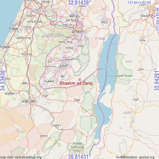
Khashm ad Daraj GPS coordinates[2]
31° 24' 58.572" North, 35° 14' 22.128" East
| Map corner | latitude | longitude |
|---|---|---|
| Upper-left | 32.01439°, | 34.53636° |
| Center: | 31.41627°, | 35.23948° |
| Lower-right: | 30.81431°, | 35.94261° |
| Map W x H: | 133.4×133.4 km | = 82.9×82.9mi |
| max Lat: | 32.54346° ⇑95.9% North |
| Khashm ad Daraj: | 31.41627° |
| min Lat: | ⇓4.1% South 31.25997° |
| min Long | Khashm ad Daraj | max Long |
| 34.24357° | 35.23948° | 35.53898° |
| W 73.8%⇐ | ⇒26.2% E |
Elevation
Elevation of Khashm ad Daraj is 534 m = 1752 ft, and this is 60.7 m = 199 ft above average elevation for this country.
| Max E: |
999 m = 3278 ft | 42.5% |
| Khashm ad Daraj | 534 m 1752 ft | |
| Avg. | 473.3 m = 1553 ft | |
Min E: |
-269 m = -883 ft | 57.5% |
See also: Palestinian Territory elevation on elevation.city.
Geographical zone
Khashm ad Daraj is located in North temperate zone (between Tropic of Cancer and the Arctic Circle). Distance of this Northern Tropic circle is 887.2 km =551.3 mi to South.| Distance of | km | miles | from Khashm ad Daraj |
|---|---|---|---|
| North Pole | 6513.9 | 4047.5 | to North |
| Arctic Circle | 3908 | 2428.3 | to North |
| Tropic Cancer | 887.2 | 551.3 | to South |
| Equator | 3493.2 | 2170.6 | to South |


Nearby cities:
15 places around Khashm ad Daraj: (largest is in red/bold)
• Ad Dayrāt
7.8 km =4.8 mi,  293°
293°
• Al Buwayb
9.8 km =6.1 mi,  302°
302°
• Al Buwayrah
14.1 km =8.8 mi, 304°
• Al Karmil
10.2 km =6.3 mi,  274°
274°
• Al Ḩīlah
14.1 km =8.8 mi, 297°
• Banī Na‘īm
13.2 km =8.2 mi,  327°
327°
• Khallat ad Dār
15 km =9.3 mi,  307°
307°
• Khallat al Mayyah
9.6 km =6 mi, 287°
• Khallat Şāliḩ
11.8 km =7.3 mi, 272°
• Qalqas
16.1 km =10 mi, 301°
• Umm Laşafā
8.2 km =5.1 mi, 285°
• Umm ad Daraj
4.9 km =3 mi, 311°
• Umm al Khayr
4.3 km =2.7 mi,  283°
283°
• Yuta
14.2 km =8.8 mi, 283°
• Zīf
11.3 km =7 mi, 300°
Sources, notices
• [Note1] Compared only with cities in Palestinian Territory existing in our database
• [Src1] Map data: © OpenStreetMap contributors (CC-BY-SA)
• [Src2] Other city data from geonames.org with taken over terms of usage.
• [Src3] Geographical zone / Annual Mean Temperature by Robert A. Rohde @ Wikipedia
