‘Arab al Furayjāt geodata
‘Arab al Furayjāt is a populated place; located in Palestinian Territory in Asia/Hebron (GMT+3) time zone. With population of 563 people, there are 385 cities with bigger population in this country. Compared to other cities in Palestinian Territory, 97.7% of cities are located further ↑North; 93.6% of cities are located further →East and 52.7% of cities have higher elevation than ‘Arab al Furayjāt. Note1


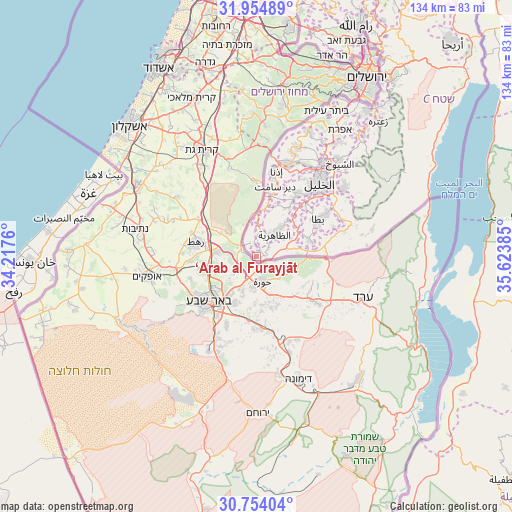
‘Arab al Furayjāt GPS coordinates[2]
31° 21' 22.968" North, 34° 55' 14.592" East
| Map corner | latitude | longitude |
|---|---|---|
| Upper-left | 31.95489°, | 34.2176° |
| Center: | 31.35638°, | 34.92072° |
| Lower-right: | 30.75404°, | 35.62385° |
| Map W x H: | 133.5×133.5 km | = 83×83mi |
| max Lat: | 32.54346° ⇑97.7% North |
| ‘Arab al Furayjāt: | 31.35638° |
| min Lat: | ⇓2.3% South 31.25997° |
| min Long | ‘Arab al Fura | max Long |
| 34.24357° | 34.92072° | 35.53898° |
| W 6.4%⇐ | ⇒93.6% E |
Elevation
Elevation of ‘Arab al Furayjāt is 464 m = 1522 ft, and this is 9.3 m = 31 ft below average elevation for this country.
| Max E: |
999 m = 3278 ft | 52.7% |
| Avg. | 473.3 m = 1553 ft | |
| ‘Arab al Furayjāt | 464 m = 1522 ft | |
Min E: |
-269 m = -883 ft | 47.3% |
See also: Palestinian Territory elevation on elevation.city.
Geographical zone
‘Arab al Furayjāt is located in North temperate zone (between Tropic of Cancer and the Arctic Circle). Distance of this Northern Tropic circle is 880.6 km =547.2 mi to South.| Distance of | km | miles | from ‘Arab al Furayjāt |
|---|---|---|---|
| North Pole | 6520.6 | 4051.7 | to North |
| Arctic Circle | 3914.7 | 2432.5 | to North |
| Tropic Cancer | 880.6 | 547.2 | to South |
| Equator | 3486.5 | 2166.4 | to South |


Nearby cities:
15 places around ‘Arab al Furayjāt: (largest is in red/bold)
• Al Burj
8.9 km =5.5 mi,  357°
357°
• Al Majd
14.1 km =8.8 mi,  11°
11°
• Ar Ramāḑīn
2.7 km =1.7 mi,  343°
343°
• As Samū‘
14.5 km =9 mi,  72°
72°
• Az̧ Z̧āhirīyah
7.7 km =4.8 mi,  40°
40°
• Aş Şūrrah
14.7 km =9.1 mi,  30°
30°
• Bayt ar Rūsh al Fawqā
10.6 km =6.6 mi,  2°
2°
• Dayr al ‘Asal al Fawqā
12.6 km =7.8 mi, 7°
• Dayr al ‘Asal at Taḩtā
13.2 km =8.2 mi, 9°
• Imrīsh
15 km =9.3 mi, 33°
• Karmah
14.7 km =9.1 mi, 43°
• Kurzah
12 km =7.5 mi, 38°
• Rābūd
12.9 km =8 mi, 44°
• Sikkah
15.2 km =9.4 mi, 8°
• Ḩadb al ‘Alqah
13.1 km =8.1 mi, 32°
Sources, notices
• [Note1] Compared only with cities in Palestinian Territory existing in our database
• [Src1] Map data: © OpenStreetMap contributors (CC-BY-SA)
• [Src2] Other city data from geonames.org with taken over terms of usage.
• [Src3] Geographical zone / Annual Mean Temperature by Robert A. Rohde @ Wikipedia
