Rafaḩ geodata
Rafaḩ (Gaza Strip) is a seat of a second-order administrative division; located in Palestinian Territory in Asia/Gaza (GMT+3) time zone. With population of 126,305 people, there are 6 cities with bigger population in this country. Compared to other cities in Palestinian Territory, 99.2% of cities are located further ↑North; 100% of cities are located further →East and 96.2% of cities have higher elevation than Rafaḩ. Note1


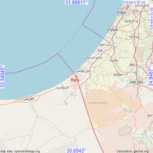
Rafaḩ GPS coordinates[2]
31° 17' 49.992" North, 34° 14' 36.852" East
| Map corner | latitude | longitude |
|---|---|---|
| Upper-left | 31.89611°, | 33.54045° |
| Center: | 31.29722°, | 34.24357° |
| Lower-right: | 30.6945°, | 34.9467° |
| Map W x H: | 133.6×133.6 km | = 83×83mi |
| max Lat: | 32.54346° ⇑99.2% North |
| Rafaḩ: | 31.29722° |
| min Lat: | ⇓0.8% South 31.25997° |
| min Long | Rafaḩ | max Long |
| 34.24357° | 34.24357° | 35.53898° |
| W 0%⇐ | ⇒100% E |
Elevation
Elevation of Rafaḩ is 30 m = 98 ft, and this is 443.3 m = 1454 ft below average elevation for this country.
| Max E: |
999 m = 3278 ft | 96.2% |
| Avg. | 473.3 m = 1553 ft | |
| Rafaḩ | 30 m = 98 ft | |
Min E: |
-269 m = -883 ft | 3.8% |
See also: Rafaḩ elevation on elevation.city.
Geographical zone
Rafaḩ is located in North temperate zone (between Tropic of Cancer and the Arctic Circle). Distance of this Northern Tropic circle is 874 km =543.1 mi to South.| Distance of | km | miles | from Rafaḩ |
|---|---|---|---|
| North Pole | 6527.1 | 4055.8 | to North |
| Arctic Circle | 3921.2 | 2436.5 | to North |
| Tropic Cancer | 874 | 543.1 | to South |
| Equator | 3479.9 | 2162.3 | to South |


Nearby cities:
15 places around Rafaḩ: (largest is in red/bold)
• Al Burayj
21.9 km =13.6 mi,  43°
43°
• Al Fukhkhārī
8.3 km =5.2 mi,  93°
93°
• Al Muşaddar
17.9 km =11.1 mi,  45°
45°
• Al Qarārah
12.6 km =7.8 mi, 47°
• An Naşr
5.9 km =3.7 mi,  107°
107°
• An Nuşayrāt
22 km =13.7 mi, 40°
• Az Zuwāydah
20.5 km =12.7 mi, 39°
• Banī Suhaylā
9.2 km =5.7 mi,  55°
55°
• Dayr al Balaḩ
16.8 km =10.4 mi, 37°
• Khuzā‘ah
11.2 km =7 mi,  84°
84°
• Khān Yūnis
7.6 km =4.7 mi, 51°
• Shūkat aş Şūfī
5.6 km =3.5 mi,  138°
138°
• Wādī as Salqā
14.5 km =9 mi, 37°
• ‘Abasān al Jadīdah
10.9 km =6.8 mi, 63°
• ‘Abasān al Kabīrah
9.5 km =5.9 mi, 75°
Sources, notices
• [Note1] Compared only with cities in Palestinian Territory existing in our database
• [Src1] Map data: © OpenStreetMap contributors (CC-BY-SA)
• [Src2] Other city data from geonames.org with taken over terms of usage.
• [Src3] Geographical zone / Annual Mean Temperature by Robert A. Rohde @ Wikipedia
