Ţūlkarm geodata
Ţūlkarm (West Bank) is a populated place; located in Palestinian Territory in Asia/Hebron (GMT+3) time zone. With population of 44,169 people, there are 9 cities with bigger population in this country. Compared to other cities in Palestinian Territory, 81.2% of cities are located further ↓South; 84.5% of cities are located further →East and 88% of cities have higher elevation than Ţūlkarm. Note1


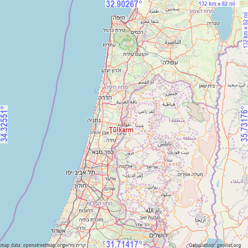
Ţūlkarm GPS coordinates[2]
32° 18' 37.332" North, 35° 1' 43.068" East
| Map corner | latitude | longitude |
|---|---|---|
| Upper-left | 32.90267°, | 34.32551° |
| Center: | 32.31037°, | 35.02863° |
| Lower-right: | 31.71417°, | 35.73176° |
| Map W x H: | 132.1×132.1 km | = 82.1×82.1mi |
| max Lat: | 32.54346° ⇑18.8% North |
| Ţūlkarm: | 32.31037° |
| min Lat: | ⇓81.2% South 31.25997° |
| min Long | Ţūlkarm | max Long |
| 34.24357° | 35.02863° | 35.53898° |
| W 15.5%⇐ | ⇒84.5% E |
Elevation
Elevation of Ţūlkarm is 117 m = 384 ft, and this is 356.3 m = 1169 ft below average elevation for this country.
| Max E: |
999 m = 3278 ft | 88% |
| Avg. | 473.3 m = 1553 ft | |
| Ţūlkarm | 117 m = 384 ft | |
Min E: |
-269 m = -883 ft | 12% |
See also: Ţūlkarm elevation on elevation.city.
Geographical zone
Ţūlkarm is located in North temperate zone (between Tropic of Cancer and the Arctic Circle). Distance of this Northern Tropic circle is 986.7 km =613.1 mi to South.| Distance of | km | miles | from Ţūlkarm |
|---|---|---|---|
| North Pole | 6414.5 | 3985.8 | to North |
| Arctic Circle | 3808.6 | 2366.6 | to North |
| Tropic Cancer | 986.7 | 613.1 | to South |
| Equator | 3592.6 | 2232.3 | to South |


Nearby cities:
15 places around Ţūlkarm: (largest is in red/bold)
• Al Jārūshīyah
4.5 km =2.8 mi,  26°
26°
• Ar Rās
7.3 km =4.5 mi,  154°
154°
• Bal‘ā
8.2 km =5.1 mi,  71°
71°
• Dayr al Ghuşūn
6.5 km =4 mi,  44°
44°
• Dhannābah
1.3 km =0.8 mi, 74°
• Far‘ūn
2.7 km =1.7 mi,  190°
190°
• Iktābah
2.9 km =1.8 mi,  51°
51°
• Kafr Jammāl
9.5 km =5.9 mi,  171°
171°
• Kafr al Labad
7.7 km =4.8 mi,  98°
98°
• Kafr Şūr
8.1 km =5 mi,  155°
155°
• Saffārīn
9.4 km =5.8 mi,  124°
124°
• Shūfah
6.3 km =3.9 mi,  128°
128°
• Zaytā
8.6 km =5.3 mi,  14°
14°
• ‘Anabtā
8.3 km =5.2 mi,  91°
91°
• ‘Attīl
7.7 km =4.8 mi, 31°
Sources, notices
• [Note1] Compared only with cities in Palestinian Territory existing in our database
• [Src1] Map data: © OpenStreetMap contributors (CC-BY-SA)
• [Src2] Other city data from geonames.org with taken over terms of usage.
• [Src3] Geographical zone / Annual Mean Temperature by Robert A. Rohde @ Wikipedia
