‘Attīl geodata
‘Attīl (West Bank) is a populated place; located in Palestinian Territory in Asia/Hebron (GMT+3) time zone. With population of 10,100 people, there are 55 cities with bigger population in this country. Compared to other cities in Palestinian Territory, 86.5% of cities are located further ↓South; 74.3% of cities are located further →East and 88.8% of cities have higher elevation than ‘Attīl. Note1


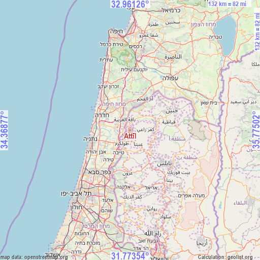
‘Attīl GPS coordinates[2]
32° 22' 9.66" North, 35° 4' 18.804" East
| Map corner | latitude | longitude |
|---|---|---|
| Upper-left | 32.96126°, | 34.36877° |
| Center: | 32.36935°, | 35.07189° |
| Lower-right: | 31.77354°, | 35.77502° |
| Map W x H: | 132.1×132.1 km | = 82.1×82.1mi |
| max Lat: | 32.54346° ⇑13.5% North |
| ‘Attīl: | 32.36935° |
| min Lat: | ⇓86.5% South 31.25997° |
| min Long | ‘Attīl | max Long |
| 34.24357° | 35.07189° | 35.53898° |
| W 25.7%⇐ | ⇒74.3% E |
Elevation
Elevation of ‘Attīl is 111 m = 364 ft, and this is 362.3 m = 1189 ft below average elevation for this country.
| Max E: |
999 m = 3278 ft | 88.8% |
| Avg. | 473.3 m = 1553 ft | |
| ‘Attīl | 111 m = 364 ft | |
Min E: |
-269 m = -883 ft | 11.2% |
See also: Palestinian Territory elevation on elevation.city.
Geographical zone
‘Attīl is located in North temperate zone (between Tropic of Cancer and the Arctic Circle). Distance of this Northern Tropic circle is 993.2 km =617.1 mi to South.| Distance of | km | miles | from ‘Attīl |
|---|---|---|---|
| North Pole | 6407.9 | 3981.7 | to North |
| Arctic Circle | 3802 | 2362.5 | to North |
| Tropic Cancer | 993.2 | 617.1 | to South |
| Equator | 3599.1 | 2236.4 | to South |


Nearby cities:
15 places around ‘Attīl: (largest is in red/bold)
• Al Jārūshīyah
3.2 km =2 mi,  219°
219°
• An Nazlah al Gharbīyah
3.9 km =2.4 mi,  17°
17°
• An Nazlah ash Sharqīyah
5.8 km =3.6 mi,  37°
37°
• Bal‘ā
5.4 km =3.4 mi,  136°
136°
• Bāqah ash Sharqīyah
4.6 km =2.9 mi,  358°
358°
• Dayr al Ghuşūn
1.9 km =1.2 mi,  165°
165°
• Dhannābah
6.8 km =4.2 mi,  204°
204°
• Iktābah
5.1 km =3.2 mi, 200°
• Kafr Rā‘ī
7.8 km =4.8 mi,  86°
86°
• Nazlat ‘Īsá
5.3 km =3.3 mi,  346°
346°
• Qaffīn
7.1 km =4.4 mi,  8°
8°
• Zaytā
2.7 km =1.7 mi,  312°
312°
• Şaydā
4.7 km =2.9 mi,  68°
68°
• Ţūlkarm
7.7 km =4.8 mi,  211°
211°
• ‘Illār
3.3 km =2.1 mi, 88°
Sources, notices
• [Note1] Compared only with cities in Palestinian Territory existing in our database
• [Src1] Map data: © OpenStreetMap contributors (CC-BY-SA)
• [Src2] Other city data from geonames.org with taken over terms of usage.
• [Src3] Geographical zone / Annual Mean Temperature by Robert A. Rohde @ Wikipedia
