Ţūbās geodata
Ţūbās (West Bank) is a seat of a second-order administrative division; located in Palestinian Territory in Asia/Hebron (GMT+3) time zone. With population of 15,591 people, there are 39 cities with bigger population in this country. Compared to other cities in Palestinian Territory, 82.2% of cities are located further ↓South; 94.7% of cities are located further ←West and 64.1% of cities have higher elevation than Ţūbās. Note1


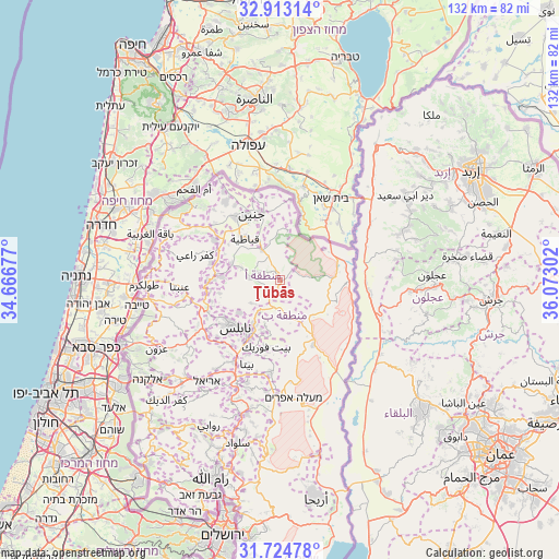
Ţūbās GPS coordinates[2]
32° 19' 15.276" North, 35° 22' 11.604" East
| Map corner | latitude | longitude |
|---|---|---|
| Upper-left | 32.91314°, | 34.66677° |
| Center: | 32.32091°, | 35.36989° |
| Lower-right: | 31.72478°, | 36.07302° |
| Map W x H: | 132.1×132.1 km | = 82.1×82.1mi |
| max Lat: | 32.54346° ⇑17.8% North |
| Ţūbās: | 32.32091° |
| min Lat: | ⇓82.2% South 31.25997° |
| min Long | Ţūbās | max Long |
| 34.24357° | 35.36989° | 35.53898° |
| W 94.7%⇐ | ⇒5.3% E |
Elevation
Elevation of Ţūbās is 375 m = 1230 ft, and this is 98.3 m = 323 ft below average elevation for this country.
| Max E: |
999 m = 3278 ft | 64.1% |
| Avg. | 473.3 m = 1553 ft | |
| Ţūbās | 375 m = 1230 ft | |
Min E: |
-269 m = -883 ft | 35.9% |
See also: Palestinian Territory elevation on elevation.city.
Geographical zone
Ţūbās is located in North temperate zone (between Tropic of Cancer and the Arctic Circle). Distance of this Northern Tropic circle is 987.8 km =613.8 mi to South.| Distance of | km | miles | from Ţūbās |
|---|---|---|---|
| North Pole | 6413.3 | 3985 | to North |
| Arctic Circle | 3807.4 | 2365.8 | to North |
| Tropic Cancer | 987.8 | 613.8 | to South |
| Equator | 3593.7 | 2233 | to South |


Nearby cities:
15 places around Ţūbās: (largest is in red/bold)
• Al Bādhān
7.8 km =4.8 mi,  206°
206°
• Al Judayyidah
6.7 km =4.2 mi,  284°
284°
• Al ‘Aqrabānīyah
7.7 km =4.8 mi,  174°
174°
• An Naşşārīyah
9.5 km =5.9 mi, 170°
• Ath Thaghrah
2.1 km =1.3 mi,  61°
61°
• Az Zabābidah
8.5 km =5.3 mi,  329°
329°
• Bayt Ḩasan
9.8 km =6.1 mi,  160°
160°
• Maythalūn
9.5 km =5.9 mi,  288°
288°
• Rābā
7.4 km =4.6 mi,  9°
9°
• Sīrīs
7.4 km =4.6 mi, 276°
• Tayāsīr
3.3 km =2.1 mi,  48°
48°
• Yāşīd
9.1 km =5.7 mi,  252°
252°
• Şīr
7 km =4.3 mi,  312°
312°
• Ţallūzah
9 km =5.6 mi,  231°
231°
• Ţammūn
4.4 km =2.7 mi, 162°
Sources, notices
• [Note1] Compared only with cities in Palestinian Territory existing in our database
• [Src1] Map data: © OpenStreetMap contributors (CC-BY-SA)
• [Src2] Other city data from geonames.org with taken over terms of usage.
• [Src3] Geographical zone / Annual Mean Temperature by Robert A. Rohde @ Wikipedia
