Ţallūzah geodata
Ţallūzah (West Bank) is a populated place; located in Palestinian Territory in Asia/Hebron (GMT+3) time zone. With population of 2,604 people, there are 196 cities with bigger population in this country. Compared to other cities in Palestinian Territory, 78.1% of cities are located further ↓South; 86.8% of cities are located further ←West and 59.3% of cities have lower elevation than Ţallūzah. Note1


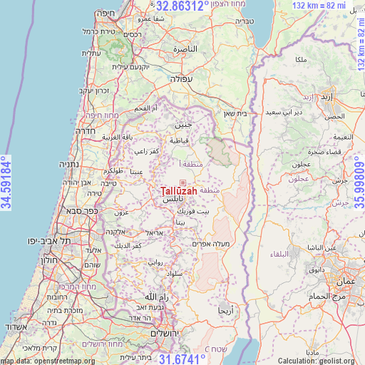
Ţallūzah GPS coordinates[2]
32° 16' 14.016" North, 35° 17' 41.856" East
| Map corner | latitude | longitude |
|---|---|---|
| Upper-left | 32.86312°, | 34.59184° |
| Center: | 32.27056°, | 35.29496° |
| Lower-right: | 31.6741°, | 35.99809° |
| Map W x H: | 132.2×132.2 km | = 82.1×82.1mi |
| max Lat: | 32.54346° ⇑21.9% North |
| Ţallūzah: | 32.27056° |
| min Lat: | ⇓78.1% South 31.25997° |
| min Long | Ţallūzah | max Long |
| 34.24357° | 35.29496° | 35.53898° |
| W 86.8%⇐ | ⇒13.2% E |
Elevation
Elevation of Ţallūzah is 543 m = 1781 ft, and this is 69.7 m = 229 ft above average elevation for this country.
| Max E: |
999 m = 3278 ft | 40.7% |
| Ţallūzah | 543 m 1781 ft | |
| Avg. | 473.3 m = 1553 ft | |
Min E: |
-269 m = -883 ft | 59.3% |
See also: Palestinian Territory elevation on elevation.city.
Geographical zone
Ţallūzah is located in North temperate zone (between Tropic of Cancer and the Arctic Circle). Distance of this Northern Tropic circle is 982.2 km =610.3 mi to South.| Distance of | km | miles | from Ţallūzah |
|---|---|---|---|
| North Pole | 6418.9 | 3988.5 | to North |
| Arctic Circle | 3813 | 2369.3 | to North |
| Tropic Cancer | 982.2 | 610.3 | to South |
| Equator | 3588.1 | 2229.5 | to South |


Nearby cities:
15 places around Ţallūzah: (largest is in red/bold)
• Al Bādhān
3.8 km =2.4 mi,  110°
110°
• Al Judayyidah
7.2 km =4.5 mi,  4°
4°
• Al ‘Aqrabānīyah
8.1 km =5 mi,  104°
104°
• Balāţah
6.6 km =4.1 mi,  187°
187°
• Bayt Imrīn
7.8 km =4.8 mi,  288°
288°
• Dayr al Ḩaţab
6.4 km =4 mi,  157°
157°
• Kafr Qallīl
8.6 km =5.3 mi, 187°
• Nablus
6.7 km =4.2 mi,  214°
214°
• Sālim
7.5 km =4.7 mi,  153°
153°
• Sīrīs
6.4 km =4 mi,  356°
356°
• Yāşīd
3.4 km =2.1 mi,  330°
330°
• Zawātā
7 km =4.3 mi,  247°
247°
• Ţammūn
8.5 km =5.3 mi,  80°
80°
• ‘Azmūţ
5.5 km =3.4 mi,  165°
165°
• ‘Aşīrah ash Shamālīyah
3.4 km =2.1 mi,  230°
230°
Sources, notices
• [Note1] Compared only with cities in Palestinian Territory existing in our database
• [Src1] Map data: © OpenStreetMap contributors (CC-BY-SA)
• [Src2] Other city data from geonames.org with taken over terms of usage.
• [Src3] Geographical zone / Annual Mean Temperature by Robert A. Rohde @ Wikipedia
