Nablus geodata
Nablus (West Bank) is a seat of a second-order administrative division; located in Palestinian Territory in Asia/Hebron (GMT+3) time zone. With population of 130,326 people, there are 5 cities with bigger population in this country. Compared to other cities in Palestinian Territory, 72.5% of cities are located further ↓South; 77.1% of cities are located further ←West and 61.8% of cities have lower elevation than Nablus. Note1


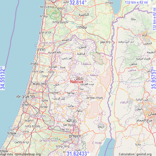
Nablus GPS coordinates[2]
32° 13' 15.996" North, 35° 15' 15.984" East
| Map corner | latitude | longitude |
|---|---|---|
| Upper-left | 32.814°, | 34.55132° |
| Center: | 32.22111°, | 35.25444° |
| Lower-right: | 31.62433°, | 35.95757° |
| Map W x H: | 132.3×132.3 km | = 82.2×82.2mi |
| max Lat: | 32.54346° ⇑27.5% North |
| Nablus: | 32.22111° |
| min Lat: | ⇓72.5% South 31.25997° |
| min Long | Nablus | max Long |
| 34.24357° | 35.25444° | 35.53898° |
| W 77.1%⇐ | ⇒22.9% E |
Elevation
Elevation of Nablus is 569 m = 1867 ft, and this is 95.7 m = 314 ft above average elevation for this country.
| Max E: |
999 m = 3278 ft | 38.2% |
| Nablus | 569 m 1867 ft | |
| Avg. | 473.3 m = 1553 ft | |
Min E: |
-269 m = -883 ft | 61.8% |
See also: Nablus elevation on elevation.city.
Geographical zone
Nablus is located in North temperate zone (between Tropic of Cancer and the Arctic Circle). Distance of this Northern Tropic circle is 976.7 km =606.9 mi to South.| Distance of | km | miles | from Nablus |
|---|---|---|---|
| North Pole | 6424.4 | 3991.9 | to North |
| Arctic Circle | 3818.5 | 2372.7 | to North |
| Tropic Cancer | 976.7 | 606.9 | to South |
| Equator | 3582.7 | 2226.2 | to South |


Nearby cities:
15 places around Nablus: (largest is in red/bold)
• Balāţah
3.1 km =1.9 mi,  108°
108°
• Bayt Wazan
3.8 km =2.4 mi,  286°
286°
• Bayt Ībā
4.6 km =2.9 mi, 293°
• Būrīn
4.1 km =2.5 mi,  185°
185°
• Dayr al Ḩaţab
6.3 km =3.9 mi,  93°
93°
• Kafr Qallīl
4.1 km =2.5 mi,  138°
138°
• Mādamā
4.5 km =2.8 mi,  209°
209°
• Rūjayb
5 km =3.1 mi,  132°
132°
• Till
4.5 km =2.8 mi,  239°
239°
• Zawātā
3.8 km =2.4 mi,  316°
316°
• Şarrah
6.1 km =3.8 mi,  257°
257°
• ‘Azmūţ
5.2 km =3.2 mi, 87°
• ‘Aşīrah al Qiblīyah
6 km =3.7 mi,  217°
217°
• ‘Aşīrah ash Shamālīyah
3.6 km =2.2 mi,  19°
19°
• ‘Irāq Būrīn
2.6 km =1.6 mi, 208°
In other languages:
- In Spanish: Siquem
- In France: Naplouse
- In German: Sichem
- In Italian: Sichem
- In Russian: Наблус
- In Chinese: 納布盧斯
Sources, notices
• [Note1] Compared only with cities in Palestinian Territory existing in our database
• [Src1] Map data: © OpenStreetMap contributors (CC-BY-SA)
• [Src2] Other city data from geonames.org with taken over terms of usage.
• [Src3] Geographical zone / Annual Mean Temperature by Robert A. Rohde @ Wikipedia
