Şānūr geodata
Şānūr (West Bank) is a populated place; located in Palestinian Territory in Asia/Hebron (GMT+3) time zone. With population of 4,141 people, there are 133 cities with bigger population in this country. Compared to other cities in Palestinian Territory, 85.2% of cities are located further ↓South; 75.8% of cities are located further ←West and 62.3% of cities have higher elevation than Şānūr. Note1


Şānūr GPS coordinates[2]
32° 21' 21.888" North, 35° 14' 43.332" East
| Map corner | latitude | longitude |
|---|---|---|
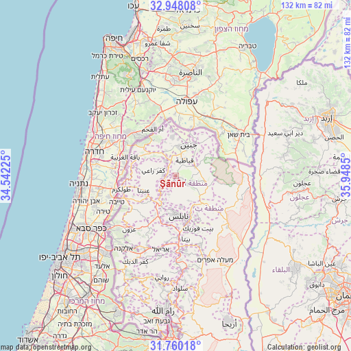
| Upper-left | 32.94808°, | 34.54225° |
| Center: | 32.35608°, | 35.24537° |
| Lower-right: | 31.76018°, | 35.9485° |
| Map W x H: | 132.1×132.1 km | = 82.1×82.1mi |
| max Lat: | 32.54346° ⇑14.8% North |
| Şānūr: | 32.35608° |
| min Lat: | ⇓85.2% South 31.25997° |
| min Long | Şānūr | max Long |
| 34.24357° | 35.24537° | 35.53898° |
| W 75.8%⇐ | ⇒24.2% E |
Elevation
Elevation of Şānūr is 386 m = 1266 ft, and this is 87.3 m = 286 ft below average elevation for this country.
| Max E: |
999 m = 3278 ft | 62.3% |
| Avg. | 473.3 m = 1553 ft | |
| Şānūr | 386 m = 1266 ft | |
Min E: |
-269 m = -883 ft | 37.7% |
See also: Palestinian Territory elevation on elevation.city.
Geographical zone
Şānūr is located in North temperate zone (between Tropic of Cancer and the Arctic Circle). Distance of this Northern Tropic circle is 991.7 km =616.2 mi to South.| Distance of | km | miles | from Şānūr |
|---|---|---|---|
| North Pole | 6409.4 | 3982.6 | to North |
| Arctic Circle | 3803.5 | 2363.4 | to North |
| Tropic Cancer | 991.7 | 616.2 | to South |
| Equator | 3597.7 | 2235.5 | to South |


Nearby cities:
15 places around Şānūr: (largest is in red/bold)
• Al Fandaqūmīyah
5.6 km =3.5 mi,  225°
225°
• Al Judayyidah
5.7 km =3.5 mi,  113°
113°
• Ar Rāmah
7 km =4.3 mi,  272°
272°
• Az Zāwiyah
2.6 km =1.6 mi,  329°
329°
• Faḩmah
6.9 km =4.3 mi,  295°
295°
• Jaba‘
4.2 km =2.6 mi,  212°
212°
• Maythalūn
2.9 km =1.8 mi, 108°
• Mirkah
4.5 km =2.8 mi,  351°
351°
• Mislīyah
5.2 km =3.2 mi,  50°
50°
• Qabāţīyah
6.9 km =4.3 mi,  28°
28°
• Sīrīs
5.3 km =3.3 mi,  125°
125°
• Şīr
6.6 km =4.1 mi,  82°
82°
• ‘Ajjah
4.7 km =2.9 mi,  276°
276°
• ‘Anzah
2.4 km =1.5 mi, 278°
• ‘Arrābah
6.8 km =4.2 mi,  323°
323°
Sources, notices
• [Note1] Compared only with cities in Palestinian Territory existing in our database
• [Src1] Map data: © OpenStreetMap contributors (CC-BY-SA)
• [Src2] Other city data from geonames.org with taken over terms of usage.
• [Src3] Geographical zone / Annual Mean Temperature by Robert A. Rohde @ Wikipedia
