Ramallah geodata
Ramallah (West Bank) is a populated place; located in Palestinian Territory in Asia/Hebron (GMT+3) time zone. With population of 24,599 people, there are 23 cities with bigger population in this country. Compared to other cities in Palestinian Territory, 61.8% of cities are located further ↑North; 64.1% of cities are located further ←West and 95.2% of cities have lower elevation than Ramallah. Note1


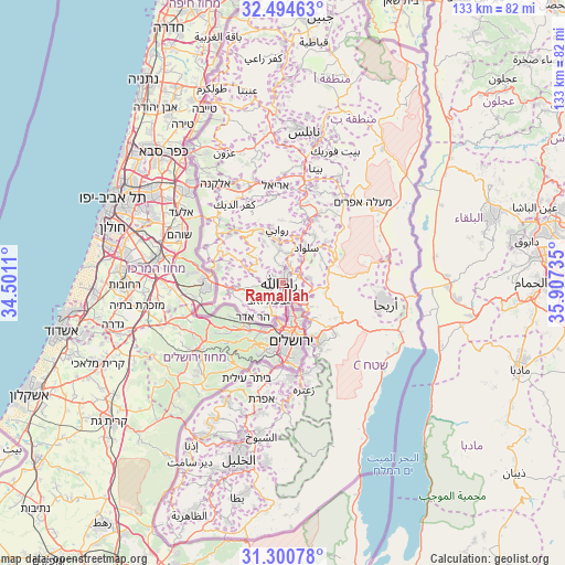
Ramallah GPS coordinates[2]
31° 53' 58.704" North, 35° 12' 15.192" East
| Map corner | latitude | longitude |
|---|---|---|
| Upper-left | 32.49463°, | 34.5011° |
| Center: | 31.89964°, | 35.20422° |
| Lower-right: | 31.30078°, | 35.90735° |
| Map W x H: | 132.7×132.7 km | = 82.5×82.5mi |
| max Lat: | 32.54346° ⇑61.8% North |
| Ramallah: | 31.89964° |
| min Lat: | ⇓38.2% South 31.25997° |
| min Long | Ramallah | max Long |
| 34.24357° | 35.20422° | 35.53898° |
| W 64.1%⇐ | ⇒35.9% E |
Elevation
Elevation of Ramallah is 879 m = 2884 ft, and this is 405.7 m = 1331 ft above average elevation for this country.
| Max E: |
999 m = 3278 ft | 4.8% |
| Ramallah | 879 m 2884 ft | |
| Avg. | 473.3 m = 1553 ft | |
Min E: |
-269 m = -883 ft | 95.2% |
See also: Palestinian Territory elevation on elevation.city.
Geographical zone
Ramallah is located in North temperate zone (between Tropic of Cancer and the Arctic Circle). Distance of this Northern Tropic circle is 941 km =584.7 mi to South.| Distance of | km | miles | from Ramallah |
|---|---|---|---|
| North Pole | 6460.2 | 4014.2 | to North |
| Arctic Circle | 3854.3 | 2395 | to North |
| Tropic Cancer | 941 | 584.7 | to South |
| Equator | 3546.9 | 2203.9 | to South |


Nearby cities:
15 places around Ramallah: (largest is in red/bold)
• Abū Qashsh
5.8 km =3.6 mi,  340°
340°
• Al Bīrah
1.6 km =1 mi,  45°
45°
• Al Judayrah
4.9 km =3 mi,  187°
187°
• Al Jīb
5.6 km =3.5 mi,  199°
199°
• Baytīn
4.6 km =2.9 mi, 49°
• Baytūnyā
3.2 km =2 mi,  263°
263°
• Burqah
4.7 km =2.9 mi,  93°
93°
• Bīr Nabālā
5.4 km =3.4 mi,  180°
180°
• Givat Zeev
5.4 km =3.4 mi,  218°
218°
• Kalandia
3.8 km =2.4 mi,  162°
162°
• Qalandiyā
4.1 km =2.5 mi,  174°
174°
• Rāfāt
3.4 km =2.1 mi, 200°
• Surdā
4.2 km =2.6 mi,  358°
358°
• ‘Ayn Qīniyā
5.9 km =3.7 mi,  300°
300°
• ‘Ayn ‘Arīk
5.9 km =3.7 mi,  277°
277°
Sources, notices
• [Note1] Compared only with cities in Palestinian Territory existing in our database
• [Src1] Map data: © OpenStreetMap contributors (CC-BY-SA)
• [Src2] Other city data from geonames.org with taken over terms of usage.
• [Src3] Geographical zone / Annual Mean Temperature by Robert A. Rohde @ Wikipedia
