Baytīn geodata
Baytīn (West Bank) is a populated place; located in Palestinian Territory in Asia/Hebron (GMT+3) time zone. With population of 2,948 people, there are 178 cities with bigger population in this country. Compared to other cities in Palestinian Territory, 59.8% of cities are located further ↑North; 74.6% of cities are located further ←West and 94.7% of cities have lower elevation than Baytīn. Note1


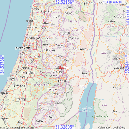
Baytīn GPS coordinates[2]
31° 55' 36.264" North, 35° 14' 27.528" East
| Map corner | latitude | longitude |
|---|---|---|
| Upper-left | 32.52156°, | 34.53786° |
| Center: | 31.92674°, | 35.24098° |
| Lower-right: | 31.32805°, | 35.94411° |
| Map W x H: | 132.7×132.7 km | = 82.5×82.5mi |
| max Lat: | 32.54346° ⇑59.8% North |
| Baytīn: | 31.92674° |
| min Lat: | ⇓40.2% South 31.25997° |
| min Long | Baytīn | max Long |
| 34.24357° | 35.24098° | 35.53898° |
| W 74.6%⇐ | ⇒25.4% E |
Elevation
Elevation of Baytīn is 863 m = 2831 ft, and this is 389.7 m = 1279 ft above average elevation for this country.
| Max E: |
999 m = 3278 ft | 5.3% |
| Baytīn | 863 m 2831 ft | |
| Avg. | 473.3 m = 1553 ft | |
Min E: |
-269 m = -883 ft | 94.7% |
See also: Palestinian Territory elevation on elevation.city.
Geographical zone
Baytīn is located in North temperate zone (between Tropic of Cancer and the Arctic Circle). Distance of this Northern Tropic circle is 944 km =586.6 mi to South.| Distance of | km | miles | from Baytīn |
|---|---|---|---|
| North Pole | 6457.1 | 4012.3 | to North |
| Arctic Circle | 3851.3 | 2393.1 | to North |
| Tropic Cancer | 944 | 586.6 | to South |
| Equator | 3549.9 | 2205.8 | to South |


Nearby cities:
15 places around Baytīn: (largest is in red/bold)
• Abū Qashsh
5.9 km =3.7 mi,  294°
294°
• Al Bīrah
3 km =1.9 mi,  231°
231°
• Aţ Ţaybah
6.3 km =3.9 mi,  61°
61°
• Burqah
3.6 km =2.2 mi,  159°
159°
• Bīr Zayt
6.5 km =4 mi,  317°
317°
• Dayr Dibwān
3 km =1.9 mi,  125°
125°
• Dūrā al Qar‘
3.8 km =2.4 mi,  339°
339°
• Jifnā
4.7 km =2.9 mi,  326°
326°
• Ramallah
4.6 km =2.9 mi, 229°
• Rammūn
5.5 km =3.4 mi,  82°
82°
• Silwād
5.8 km =3.6 mi,  19°
19°
• Surdā
3.7 km =2.3 mi, 287°
• Yabrūd
5.2 km =3.2 mi,  4°
4°
• ‘Ayn Sīnyā
5.1 km =3.2 mi,  345°
345°
• ‘Ayn Yabrūd
2.7 km =1.7 mi, 21°
Sources, notices
• [Note1] Compared only with cities in Palestinian Territory existing in our database
• [Src1] Map data: © OpenStreetMap contributors (CC-BY-SA)
• [Src2] Other city data from geonames.org with taken over terms of usage.
• [Src3] Geographical zone / Annual Mean Temperature by Robert A. Rohde @ Wikipedia
