Hebron geodata
Hebron (West Bank) is a seat of a second-order administrative division; located in Palestinian Territory in Asia/Hebron (GMT+3) time zone. With population of 160,470 people, there are 4 cities with bigger population in this country. Compared to other cities in Palestinian Territory, 84.7% of cities are located further ↑North; 70.5% of cities are located further →East and 96.4% of cities have lower elevation than Hebron. Note1


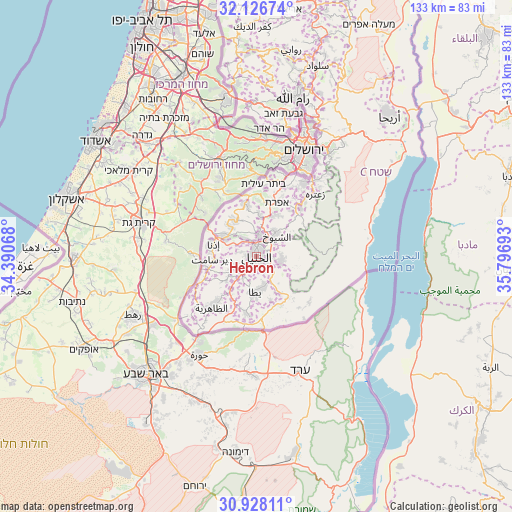
Hebron GPS coordinates[2]
31° 31' 45.66" North, 35° 5' 37.68" East
| Map corner | latitude | longitude |
|---|---|---|
| Upper-left | 32.12674°, | 34.39068° |
| Center: | 31.52935°, | 35.0938° |
| Lower-right: | 30.92811°, | 35.79693° |
| Map W x H: | 133.3×133.3 km | = 82.8×82.8mi |
| max Lat: | 32.54346° ⇑84.7% North |
| Hebron: | 31.52935° |
| min Lat: | ⇓15.3% South 31.25997° |
| min Long | Hebron | max Long |
| 34.24357° | 35.0938° | 35.53898° |
| W 29.5%⇐ | ⇒70.5% E |
Elevation
Elevation of Hebron is 903 m = 2963 ft, and this is 429.7 m = 1410 ft above average elevation for this country.
| Max E: |
999 m = 3278 ft | 3.6% |
| Hebron | 903 m 2963 ft | |
| Avg. | 473.3 m = 1553 ft | |
Min E: |
-269 m = -883 ft | 96.4% |
See also: Hebron elevation on elevation.city.
Geographical zone
Hebron is located in North temperate zone (between Tropic of Cancer and the Arctic Circle). Distance of this Northern Tropic circle is 899.8 km =559.1 mi to South.| Distance of | km | miles | from Hebron |
|---|---|---|---|
| North Pole | 6501.3 | 4039.7 | to North |
| Arctic Circle | 3895.4 | 2420.5 | to North |
| Tropic Cancer | 899.8 | 559.1 | to South |
| Equator | 3505.7 | 2178.3 | to South |


Nearby cities:
15 places around Hebron: (largest is in red/bold)
• Al Buq‘ah
4.9 km =3 mi,  73°
73°
• Al Buwayrah
5.1 km =3.2 mi,  154°
154°
• Al Ḩīlah
6.2 km =3.9 mi,  168°
168°
• Ar Rīḩīyah
6.8 km =4.2 mi,  192°
192°
• Ash Shuyūkh
7.4 km =4.6 mi,  52°
52°
• Banī Na‘īm
6.8 km =4.2 mi,  102°
102°
• Bayt Kāḩil
5.3 km =3.3 mi,  328°
328°
• Bayt ‘Īnūn
4.4 km =2.7 mi,  41°
41°
• Dūrā
6.6 km =4.1 mi,  248°
248°
• Khallat ad Dār
4 km =2.5 mi, 152°
• Qalqas
4.1 km =2.5 mi,  177°
177°
• Qilā‘ Zaytā
3.7 km =2.3 mi, 44°
• Sa‘īr
7 km =4.3 mi, 38°
• Taffūḩ
4.3 km =2.7 mi,  283°
283°
• Ḩalḩūl
5.7 km =3.5 mi,  7°
7°
Sources, notices
• [Note1] Compared only with cities in Palestinian Territory existing in our database
• [Src1] Map data: © OpenStreetMap contributors (CC-BY-SA)
• [Src2] Other city data from geonames.org with taken over terms of usage.
• [Src3] Geographical zone / Annual Mean Temperature by Robert A. Rohde @ Wikipedia
