Prazeres geodata
Prazeres (Madeira) is a populated place; located in Portugal in Atlantic/Madeira (GMT+1) time zone. With population of 672 people, there are 800 cities with bigger population in this country. Compared to other cities in Portugal, 97.5% of cities are located further ↑North; 92.9% of cities are located further →East and 95.7% of cities have lower elevation than Prazeres. Note1


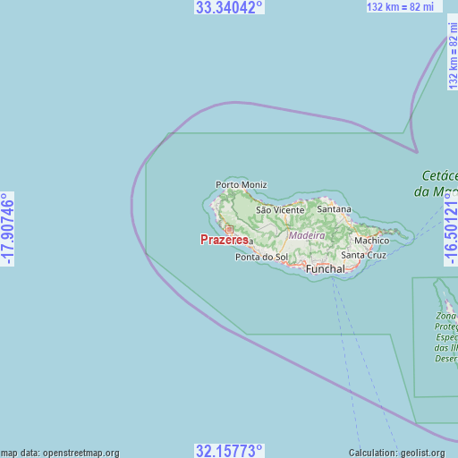
Prazeres GPS coordinates[2]
32° 45' 3.744" North, 17° 12' 15.588" West
| Map corner | latitude | longitude |
|---|---|---|
| Upper-left | 33.34042°, | -17.90746° |
| Center: | 32.75104°, | -17.20433° |
| Lower-right: | 32.15773°, | -16.50121° |
| Map W x H: | 131.5×131.5 km | = 81.7×81.7mi |
| max Lat: | 42.11337° ⇑97.5% North |
| Prazeres: | 32.75104° |
| min Lat: | ⇓2.5% South 32.6448° |
| min Long | Prazeres | max Long |
| -31.17847° | -17.20433° | -6.27308° |
| W 7.1%⇐ | ⇒92.9% E |
Elevation
Elevation of Prazeres is 638 m = 2093 ft, and this is 461 m = 1512 ft above average elevation for this country.
| Max E: |
1008 m = 3307 ft | 4.3% |
| Prazeres | 638 m 2093 ft | |
| Avg. | 177 m = 581 ft | |
Min E: |
-128 m = -420 ft | 95.7% |
See also: Portugal elevation on elevation.city.
Geographical zone
Prazeres is located in North temperate zone (between Tropic of Cancer and the Arctic Circle). Distance of this Northern Tropic circle is 1035.7 km =643.6 mi to South.| Distance of | km | miles | from Prazeres |
|---|---|---|---|
| North Pole | 6365.5 | 3955.3 | to North |
| Arctic Circle | 3759.6 | 2336.1 | to North |
| Tropic Cancer | 1035.7 | 643.6 | to South |
| Equator | 3641.6 | 2262.8 | to South |


Nearby cities:
15 places around Prazeres: (largest is in red/bold)
• Arco da Calheta
6.5 km =4 mi,  128°
128°
• Calheta
4.3 km =2.7 mi,  152°
152°
• Campanário
18.4 km =11.4 mi,  121°
121°
• Canhas
11.7 km =7.3 mi, 122°
• Estreito da Calheta
2.3 km =1.4 mi, 133°
• Fajã da Ovelha
3.8 km =2.4 mi,  313°
313°
• Lugar de Baixo
13.6 km =8.5 mi, 125°
• Madalena do Mar
8.5 km =5.3 mi, 130°
• Paul do Mar
2.6 km =1.6 mi,  290°
290°
• Ponta do Pargo
7.9 km =4.9 mi,  328°
328°
• Ponta do Sol
12.6 km =7.8 mi, 129°
• Porto Moniz
13.3 km =8.3 mi,  15°
15°
• Ribeira Brava
15.7 km =9.8 mi, 122°
• Seixal
12 km =7.5 mi,  47°
47°
• São Vicente
15.9 km =9.9 mi,  71°
71°
Sources, notices
• [Note1] Compared only with cities in Portugal existing in our database
• [Src1] Map data: © OpenStreetMap contributors (CC-BY-SA)
• [Src2] Other city data from geonames.org with taken over terms of usage.
• [Src3] Geographical zone / Annual Mean Temperature by Robert A. Rohde @ Wikipedia
