Fontes geodata
Fontes (Santarém) is a populated place; located in Portugal in Europe/Lisbon (GMT+1) time zone. With population of 627 people, there are 805 cities with bigger population in this country. Compared to other cities in Portugal, 50.2% of cities are located further ↑North; 72.1% of cities are located further ←West and 74% of cities have lower elevation than Fontes. Note1


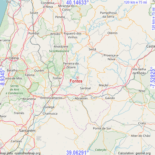
Fontes GPS coordinates[2]
39° 36' 24.264" North, 8° 13' 52.932" West
| Map corner | latitude | longitude |
|---|---|---|
| Upper-left | 40.14633°, | -8.9345° |
| Center: | 39.60674°, | -8.23137° |
| Lower-right: | 39.06291°, | -7.52825° |
| Map W x H: | 120.5×120.5 km | = 74.9×74.9mi |
| max Lat: | 42.11337° ⇑50.2% North |
| Fontes: | 39.60674° |
| min Lat: | ⇓49.8% South 32.6448° |
| min Long | Fontes | max Long |
| -31.17847° | -8.23137° | -6.27308° |
| W 72.1%⇐ | ⇒27.9% E |
Elevation
Elevation of Fontes is 227 m = 745 ft, and this is 50 m = 164 ft above average elevation for this country.
| Max E: |
1008 m = 3307 ft | 26% |
| Fontes | 227 m 745 ft | |
| Avg. | 177 m = 581 ft | |
Min E: |
-128 m = -420 ft | 74% |
See also: Portugal elevation on elevation.city.
Geographical zone
Fontes is located in North temperate zone (between Tropic of Cancer and the Arctic Circle). Distance of this Northern Tropic circle is 1797.9 km =1117.2 mi to South.| Distance of | km | miles | from Fontes |
|---|---|---|---|
| North Pole | 5603.2 | 3481.7 | to North |
| Arctic Circle | 2997.3 | 1862.4 | to North |
| Tropic Cancer | 1797.9 | 1117.2 | to South |
| Equator | 4403.9 | 2736.5 | to South |


Nearby cities:
15 places around Fontes: (largest is in red/bold)
• Abrantes
15.8 km =9.8 mi,  170°
170°
• Alferrarede
14.8 km =9.2 mi,  157°
157°
• Constância
16.9 km =10.5 mi,  212°
212°
• Ferreira do Zêzere
11 km =6.8 mi,  331°
331°
• Madalena
18.8 km =11.7 mi,  257°
257°
• Martinchel
10.4 km =6.5 mi,  221°
221°
• Montalvinho
14.9 km =9.3 mi,  203°
203°
• Montalvo
14.9 km =9.3 mi, 203°
• Pego
17.6 km =10.9 mi, 156°
• Praia do Ribatejo
18.6 km =11.6 mi, 213°
• Santa Margarida da Coutada
18.9 km =11.7 mi, 202°
• Sardoal
10 km =6.2 mi,  143°
143°
• Tomar
15.2 km =9.4 mi,  268°
268°
• Tramagal
17.5 km =10.9 mi,  185°
185°
• Vila de Rei
10.6 km =6.6 mi,  43°
43°
Sources, notices
• [Note1] Compared only with cities in Portugal existing in our database
• [Src1] Map data: © OpenStreetMap contributors (CC-BY-SA)
• [Src2] Other city data from geonames.org with taken over terms of usage.
• [Src3] Geographical zone / Annual Mean Temperature by Robert A. Rohde @ Wikipedia
