Constância geodata
Constância (Santarém) is a seat of a second-order administrative division; located in Portugal in Europe/Lisbon (GMT+1) time zone. With population of 993 people, there are 752 cities with bigger population in this country. Compared to other cities in Portugal, 53.2% of cities are located further ↑North; 66.9% of cities are located further ←West and 76.9% of cities have higher elevation than Constância. Note1


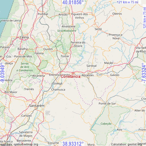
Constância GPS coordinates[2]
39° 28' 40.656" North, 8° 20' 10.896" West
| Map corner | latitude | longitude |
|---|---|---|
| Upper-left | 40.01856°, | -9.03949° |
| Center: | 39.47796°, | -8.33636° |
| Lower-right: | 38.93312°, | -7.63324° |
| Map W x H: | 120.7×120.7 km | = 75×75mi |
| max Lat: | 42.11337° ⇑53.2% North |
| Constância: | 39.47796° |
| min Lat: | ⇓46.8% South 32.6448° |
| min Long | Constância | max Long |
| -31.17847° | -8.33636° | -6.27308° |
| W 66.9%⇐ | ⇒33.1% E |
Elevation
Elevation of Constância is 37 m = 121 ft, and this is 140 m = 459 ft below average elevation for this country.
| Max E: |
1008 m = 3307 ft | 76.9% |
| Avg. | 177 m = 581 ft | |
| Constância | 37 m = 121 ft | |
Min E: |
-128 m = -420 ft | 23.1% |
See also: Portugal elevation on elevation.city.
Geographical zone
Constância is located in North temperate zone (between Tropic of Cancer and the Arctic Circle). Distance of this Northern Tropic circle is 1783.6 km =1108.3 mi to South.| Distance of | km | miles | from Constância |
|---|---|---|---|
| North Pole | 5617.5 | 3490.6 | to North |
| Arctic Circle | 3011.6 | 1871.3 | to North |
| Tropic Cancer | 1783.6 | 1108.3 | to South |
| Equator | 4389.5 | 2727.5 | to South |


Nearby cities:
15 places around Constância: (largest is in red/bold)
• Abrantes
11.8 km =7.3 mi,  96°
96°
• Alferrarede
14.6 km =9.1 mi,  87°
87°
• Entroncamento
11.3 km =7 mi,  263°
263°
• Madalena
14 km =8.7 mi,  317°
317°
• Martinchel
6.8 km =4.2 mi,  18°
18°
• Montalvinho
3.2 km =2 mi,  79°
79°
• Montalvo
3.2 km =2 mi, 79°
• Paialvo
14.8 km =9.2 mi,  310°
310°
• Pinheiro Grande
12.7 km =7.9 mi,  221°
221°
• Praia do Ribatejo
1.7 km =1.1 mi, 223°
• Santa Margarida da Coutada
3.5 km =2.2 mi,  151°
151°
• São Miguel de Rio Torto
11.4 km =7.1 mi,  115°
115°
• Tomar
15.1 km =9.4 mi,  335°
335°
• Tramagal
8 km =5 mi,  112°
112°
• Vila Nova da Barquinha
8.8 km =5.5 mi, 257°
Sources, notices
• [Note1] Compared only with cities in Portugal existing in our database
• [Src1] Map data: © OpenStreetMap contributors (CC-BY-SA)
• [Src2] Other city data from geonames.org with taken over terms of usage.
• [Src3] Geographical zone / Annual Mean Temperature by Robert A. Rohde @ Wikipedia
