Ferreira do Zêzere geodata
Ferreira do Zêzere (Santarém) is a seat of a second-order administrative division; located in Portugal in Europe/Lisbon (GMT+1) time zone. In our database, there are 824 cities with bigger population. Compared to other cities in Portugal, 50.9% of cities are located further ↓South; 69.5% of cities are located further ←West and 84.6% of cities have lower elevation than Ferreira do Zêzere. Note1
Administrative division(s):
- Level 1: Santarém
- Level 2: Ferreira do Zêzere
- Level 3: Ferreira do Zêzere


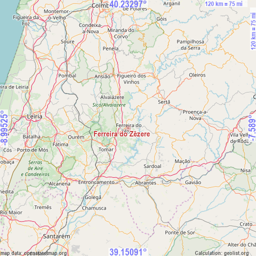
Ferreira do Zêzere GPS coordinates[2]
39° 41' 38.616" North, 8° 17' 31.668" West
| Map corner | latitude | longitude |
|---|---|---|
| Upper-left | 40.23297°, | -8.99525° |
| Center: | 39.69406°, | -8.29213° |
| Lower-right: | 39.15091°, | -7.589° |
| Map W x H: | 120.3×120.3 km | = 74.8×74.8mi |
| max Lat: | 42.11337° ⇑49.1% North |
| Ferreira do Zêzere: | 39.69406° |
| min Lat: | ⇓50.9% South 32.6448° |
| min Long | Ferreira do Zê | max Long |
| -31.17847° | -8.29213° | -6.27308° |
| W 69.5%⇐ | ⇒30.5% E |
Elevation
Elevation of Ferreira do Zêzere is 355 m = 1165 ft, and this is 178 m = 584 ft above average elevation for this country.
| Max E: |
1008 m = 3307 ft | 15.4% |
| Ferreira do Zêzere | 355 m 1165 ft | |
| Avg. | 177 m = 581 ft | |
Min E: |
-128 m = -420 ft | 84.6% |
See also: Portugal elevation on elevation.city.
Geographical zone
Ferreira do Zêzere is located in North temperate zone (between Tropic of Cancer and the Arctic Circle). Distance of this Northern Tropic circle is 1807.6 km =1123.2 mi to South.| Distance of | km | miles | from Ferreira do Zêzere |
|---|---|---|---|
| North Pole | 5593.5 | 3475.6 | to North |
| Arctic Circle | 2987.6 | 1856.4 | to North |
| Tropic Cancer | 1807.6 | 1123.2 | to South |
| Equator | 4413.6 | 2742.5 | to South |


Nearby cities:
15 places around Ferreira do Zêzere: (largest is in red/bold)
• Alferrarede
25.8 km =16 mi,  155°
155°
• Alvaiázere
16.1 km =10 mi,  332°
332°
• Constância
24.3 km =15.1 mi,  188°
188°
• Figueiró dos Vinhos
23.4 km =14.5 mi,  3°
3°
• Fontes
11 km =6.8 mi,  151°
151°
• Madalena
19 km =11.8 mi,  224°
224°
• Martinchel
17.6 km =10.9 mi, 185°
• Montalvinho
23.4 km =14.5 mi,  181°
181°
• Montalvo
23.4 km =14.5 mi, 181°
• Paialvo
20.9 km =13 mi,  226°
226°
• Praia do Ribatejo
25.8 km =16 mi, 191°
• Sardoal
21 km =13 mi, 147°
• Sertã
20.6 km =12.8 mi,  54°
54°
• Tomar
14.3 km =8.9 mi, 224°
• Vila de Rei
12.7 km =7.9 mi,  99°
99°
Sources, notices
• [Note1] Compared only with cities in Portugal existing in our database
• [Src1] Map data: © OpenStreetMap contributors (CC-BY-SA)
• [Src2] Other city data from geonames.org with taken over terms of usage.
• [Src3] Geographical zone / Annual Mean Temperature by Robert A. Rohde @ Wikipedia
