Paialvo geodata
Paialvo (Santarém) is a populated place; located in Portugal in Europe/Lisbon (GMT+1) time zone. With population of 2,599 people, there are 606 cities with bigger population in this country. Compared to other cities in Portugal, 51% of cities are located further ↑North; 56.9% of cities are located further ←West and 53.6% of cities have higher elevation than Paialvo. Note1


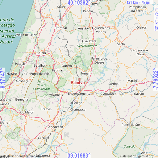
Paialvo GPS coordinates[2]
39° 33' 50.364" North, 8° 28' 6.06" West
| Map corner | latitude | longitude |
|---|---|---|
| Upper-left | 40.10392°, | -9.17147° |
| Center: | 39.56399°, | -8.46835° |
| Lower-right: | 39.01983°, | -7.76522° |
| Map W x H: | 120.5×120.5 km | = 74.9×74.9mi |
| max Lat: | 42.11337° ⇑51% North |
| Paialvo: | 39.56399° |
| min Lat: | ⇓49% South 32.6448° |
| min Long | Paialvo | max Long |
| -31.17847° | -8.46835° | -6.27308° |
| W 56.9%⇐ | ⇒43.1% E |
Elevation
Elevation of Paialvo is 98 m = 322 ft, and this is 79 m = 259 ft below average elevation for this country.
| Max E: |
1008 m = 3307 ft | 53.6% |
| Avg. | 177 m = 581 ft | |
| Paialvo | 98 m = 322 ft | |
Min E: |
-128 m = -420 ft | 46.4% |
See also: Portugal elevation on elevation.city.
Geographical zone
Paialvo is located in North temperate zone (between Tropic of Cancer and the Arctic Circle). Distance of this Northern Tropic circle is 1793.2 km =1114.2 mi to South.| Distance of | km | miles | from Paialvo |
|---|---|---|---|
| North Pole | 5608 | 3484.6 | to North |
| Arctic Circle | 3002.1 | 1865.4 | to North |
| Tropic Cancer | 1793.2 | 1114.2 | to South |
| Equator | 4399.1 | 2733.5 | to South |


Nearby cities:
15 places around Paialvo: (largest is in red/bold)
• Constância
14.8 km =9.2 mi,  130°
130°
• Entroncamento
10.8 km =6.7 mi,  179°
179°
• Fátima
17 km =10.6 mi,  291°
291°
• Golegã
17.8 km =11.1 mi, 184°
• Madalena
2.1 km =1.3 mi,  66°
66°
• Martinchel
13.8 km =8.6 mi,  102°
102°
• Montalvinho
17 km =10.6 mi,  121°
121°
• Montalvo
17 km =10.6 mi, 121°
• Ourém
13.7 km =8.5 mi,  309°
309°
• Praia do Ribatejo
14.8 km =9.2 mi,  136°
136°
• Riachos
13.8 km =8.6 mi,  196°
196°
• Santa Margarida da Coutada
18.2 km =11.3 mi, 134°
• Tomar
6.6 km =4.1 mi,  50°
50°
• Torres Novas
11.7 km =7.3 mi,  213°
213°
• Vila Nova da Barquinha
11.8 km =7.3 mi,  166°
166°
Sources, notices
• [Note1] Compared only with cities in Portugal existing in our database
• [Src1] Map data: © OpenStreetMap contributors (CC-BY-SA)
• [Src2] Other city data from geonames.org with taken over terms of usage.
• [Src3] Geographical zone / Annual Mean Temperature by Robert A. Rohde @ Wikipedia
