Pinheiro Grande geodata
Pinheiro Grande (Santarém) is a populated place; located in Portugal in Europe/Lisbon (GMT+1) time zone. With population of 1,051 people, there are 744 cities with bigger population in this country. Compared to other cities in Portugal, 56.6% of cities are located further ↑North; 60.1% of cities are located further ←West and 72.1% of cities have higher elevation than Pinheiro Grande. Note1


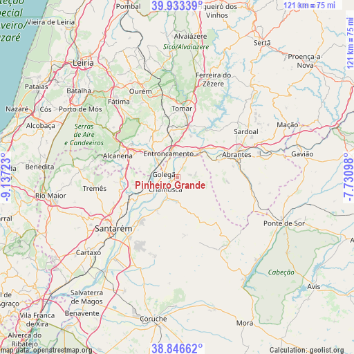
Pinheiro Grande GPS coordinates[2]
39° 23' 31.632" North, 8° 26' 2.76" West
| Map corner | latitude | longitude |
|---|---|---|
| Upper-left | 39.93339°, | -9.13723° |
| Center: | 39.39212°, | -8.4341° |
| Lower-right: | 38.84662°, | -7.73098° |
| Map W x H: | 120.8×120.8 km | = 75.1×75.1mi |
| max Lat: | 42.11337° ⇑56.6% North |
| Pinheiro Grande: | 39.39212° |
| min Lat: | ⇓43.4% South 32.6448° |
| min Long | Pinheiro Grande | max Long |
| -31.17847° | -8.4341° | -6.27308° |
| W 60.1%⇐ | ⇒39.9% E |
Elevation
Elevation of Pinheiro Grande is 46 m = 151 ft, and this is 131 m = 430 ft below average elevation for this country.
| Max E: |
1008 m = 3307 ft | 72.1% |
| Avg. | 177 m = 581 ft | |
| Pinheiro Grande | 46 m = 151 ft | |
Min E: |
-128 m = -420 ft | 27.9% |
See also: Portugal elevation on elevation.city.
Geographical zone
Pinheiro Grande is located in North temperate zone (between Tropic of Cancer and the Arctic Circle). Distance of this Northern Tropic circle is 1774.1 km =1102.4 mi to South.| Distance of | km | miles | from Pinheiro Grande |
|---|---|---|---|
| North Pole | 5627.1 | 3496.5 | to North |
| Arctic Circle | 3021.2 | 1877.3 | to North |
| Tropic Cancer | 1774.1 | 1102.4 | to South |
| Equator | 4380 | 2721.6 | to South |


Nearby cities:
15 places around Pinheiro Grande: (largest is in red/bold)
• Azinhaga
9.6 km =6 mi,  239°
239°
• Constância
12.7 km =7.9 mi,  41°
41°
• Entroncamento
8.7 km =5.4 mi,  341°
341°
• Golegã
4.7 km =2.9 mi,  287°
287°
• Martinchel
19.2 km =11.9 mi,  33°
33°
• Montalvinho
15.3 km =9.5 mi,  48°
48°
• Montalvo
15.3 km =9.5 mi, 48°
• Praia do Ribatejo
11 km =6.8 mi, 41°
• Riachos
9 km =5.6 mi,  310°
310°
• Santa Margarida da Coutada
12 km =7.5 mi,  57°
57°
• São Miguel de Rio Torto
19.2 km =11.9 mi,  76°
76°
• São Vicente do Paul
16.9 km =10.5 mi,  253°
253°
• Torres Novas
13.2 km =8.2 mi, 314°
• Tramagal
17.1 km =10.6 mi,  67°
67°
• Vila Nova da Barquinha
7.6 km =4.7 mi,  358°
358°
Sources, notices
• [Note1] Compared only with cities in Portugal existing in our database
• [Src1] Map data: © OpenStreetMap contributors (CC-BY-SA)
• [Src2] Other city data from geonames.org with taken over terms of usage.
• [Src3] Geographical zone / Annual Mean Temperature by Robert A. Rohde @ Wikipedia
