Povoação geodata
Povoação (Azores) is a populated place; located in Portugal in Atlantic/Azores (GMT+0) time zone. With population of 2,161 people, there are 633 cities with bigger population in this country. Compared to other cities in Portugal, 87.3% of cities are located further ↑North; 93.4% of cities are located further →East and 58.9% of cities have higher elevation than Povoação. Note1


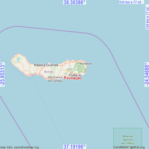
Povoação GPS coordinates[2]
37° 45' 0" North, 25° 15' 0" West
| Map corner | latitude | longitude |
|---|---|---|
| Upper-left | 38.30386°, | -25.95313° |
| Center: | 37.75°, | -25.25° |
| Lower-right: | 37.19196°, | -24.54688° |
| Map W x H: | 123.6×123.6 km | = 76.8×76.8mi |
| max Lat: | 42.11337° ⇑87.3% North |
| Povoação: | 37.75° |
| min Lat: | ⇓12.7% South 32.6448° |
| min Long | Povoação | max Long |
| -31.17847° | -25.25° | -6.27308° |
| W 6.6%⇐ | ⇒93.4% E |
Elevation
Elevation of Povoação is 81 m = 266 ft, and this is 96 m = 315 ft below average elevation for this country.
| Max E: |
1008 m = 3307 ft | 58.9% |
| Avg. | 177 m = 581 ft | |
| Povoação | 81 m = 266 ft | |
Min E: |
-128 m = -420 ft | 41.1% |
See also: Portugal elevation on elevation.city.
Geographical zone
Povoação is located in North temperate zone (between Tropic of Cancer and the Arctic Circle). Distance of this Northern Tropic circle is 1591.5 km =988.9 mi to South.| Distance of | km | miles | from Povoação |
|---|---|---|---|
| North Pole | 5809.7 | 3610 | to North |
| Arctic Circle | 3203.8 | 1990.7 | to North |
| Tropic Cancer | 1591.5 | 988.9 | to South |
| Equator | 4197.4 | 2608.1 | to South |


Nearby cities:
15 places around Povoação: (largest is in red/bold)
• Cabouco
27.9 km =17.3 mi,  273°
273°
• Fenais da Ajuda
13 km =8.1 mi,  329°
329°
• Furnas
6 km =3.7 mi,  298°
298°
• Lagoa
28.3 km =17.6 mi, 268°
• Maia
15.3 km =9.5 mi,  306°
306°
• Ponta Garça
10.9 km =6.8 mi,  250°
250°
• Rabo de Peixe
30 km =18.6 mi,  282°
282°
• Ribeira Grande
25.1 km =15.6 mi,  288°
288°
• Ribeira Quente
4.8 km =3 mi, 247°
• Ribeira Seca
15.1 km =9.4 mi,  258°
258°
• Ribeira Seca
26 km =16.2 mi, 286°
• Ribeira das Tainhas
14.1 km =8.8 mi, 255°
• Senhora do Rosário
12.8 km =8 mi,  43°
43°
• Vila Franca do Campo
16.5 km =10.3 mi, 257°
• Água de Pau
23.2 km =14.4 mi, 262°
Sources, notices
• [Note1] Compared only with cities in Portugal existing in our database
• [Src1] Map data: © OpenStreetMap contributors (CC-BY-SA)
• [Src2] Other city data from geonames.org with taken over terms of usage.
• [Src3] Geographical zone / Annual Mean Temperature by Robert A. Rohde @ Wikipedia
